 Route Editor

| Guide | ♦ | 4 Triplogs | 0 Topics |
details | drive | permit | forecast | 🔥 route |
stats |
photos | triplogs | topics | location |
| 71 | 4 | 0 |
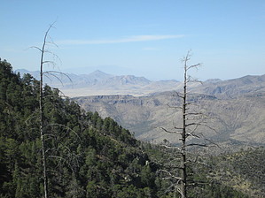
  If you begin your trip at the northern trailhead, on FR 42, you'll start among scrub oak and yucca on a dry slope and climb 2,000 feet, first to Ida Saddle and then to Barfoot Park. Vegetation along lower stretches of the trail is stunted enough to provide occasional views of the rocky bluffs and forested slopes that hem in Pinery Canyon. Switchbacks rule along much of this part of the trail as it climbs from oak-juniper woodlands into a mature pine forest. However, it first passes through an old burned area that in 1953 was the site of a large fire called the Ida Burn. The burn is marked with a sign, and nature is well on its way to reforesting the area. Above the burn, one of the most impressive stands of pines in the Chiricahuas shades the trail and carpets it with pine needles. At Ida Saddle, you may choose to bushwhack your way along game trails and rough pathways over to the twin summits of Ida Peak (the easternmost one has the best view). From the saddle, it's a reasonably easy mile to Barfoot Park and trail's end. If you begin your trip at the northern trailhead, on FR 42, you'll start among scrub oak and yucca on a dry slope and climb 2,000 feet, first to Ida Saddle and then to Barfoot Park. Vegetation along lower stretches of the trail is stunted enough to provide occasional views of the rocky bluffs and forested slopes that hem in Pinery Canyon. Switchbacks rule along much of this part of the trail as it climbs from oak-juniper woodlands into a mature pine forest. However, it first passes through an old burned area that in 1953 was the site of a large fire called the Ida Burn. The burn is marked with a sign, and nature is well on its way to reforesting the area. Above the burn, one of the most impressive stands of pines in the Chiricahuas shades the trail and carpets it with pine needles. At Ida Saddle, you may choose to bushwhack your way along game trails and rough pathways over to the twin summits of Ida Peak (the easternmost one has the best view). From the saddle, it's a reasonably easy mile to Barfoot Park and trail's end.
Check out the Official Route and Triplogs. Note This is a moderately difficult hike. Leave No Trace and +Add a Triplog after your hike to support this local community. One-Way Notice This hike is listed as One-Way. When hiking several trails on a single "hike", log it with a generic name that describes the hike. Then link the trails traveled, check out the example. | |||||||||||||||||||||||||||||||||||||||||||||||||||||||||||||||||||||||||||||||||||||||


