 Route Editor

| Guide | ♦ | 1 Triplog | 0 Topics |
details | drive | permit | forecast | 🔥 route |
stats |
photos | triplog | topics | location |
| 28 | 1 | 0 |
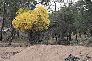
I'm Mark Thurman and this is 262B! by markthurman53   You won’t find any trail sign marking the Hughes Tank Trail 262B, but about 1.8 miles in from Turkey Canyon Road along the Turkey Pen Trail #262 is a signed intersection for the Fife Canyon Trail #273. This is also the Hughes Tank Trail, as shown on some maps. The Hughes Tank trail is 1.3 miles long and goes to Hughes Tank ending 0.1 miles later at the junction with the Upper Rock Creek Trail #259. You won’t find any trail sign marking the Hughes Tank Trail 262B, but about 1.8 miles in from Turkey Canyon Road along the Turkey Pen Trail #262 is a signed intersection for the Fife Canyon Trail #273. This is also the Hughes Tank Trail, as shown on some maps. The Hughes Tank trail is 1.3 miles long and goes to Hughes Tank ending 0.1 miles later at the junction with the Upper Rock Creek Trail #259.By Chiricahua Mountain standards, this trail is relatively easy to follow. You shouldn’t have any issues losing it if you keep an eye out. The Trail is through an oak, juniper, pine grassland forest, and the trail can get a little vague in the grassland areas. The first 0.2 miles, the trail crosses over a 200-foot hill to a saddle that separates Turkey Pen Creek from Rock Creek. From this saddle, the trail is downhill for the next mile to Hughes Tank. This tank was dry when I was there in October. At the junction with the Rock Creek Trail is a sign pointing out the Rock Creek Trail and the Fife Canyon Trail. Other than a sign pointing to Hughes Tank, there is no sign indicating the Hughes Tank Trail.
Check out the Official Route and Triplog. Leave No Trace and +Add a Triplog after your hike to support this local community. One-Way Notice This hike is listed as One-Way. When hiking several trails on a single "hike", log it with a generic name that describes the hike. Then link the trails traveled, check out the example. | ||||||||||||||||||||||||||||||||||||||||||||||||||||||||||||||||||||||||||||||||||||||||||||||||||||||


