 Route Editor

| Guide | ♦ | 7 Triplogs | 0 Topics |
details | drive | permit | forecast | route |
stats |
photos | triplogs | topics | location |
| 172 | 7 | 0 |
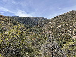
Shady climb from Powers Garden to West Divide by jacobemerick   Overview OverviewThis trail provides a mostly shaded, relatively easy climb from Powers Garden to the West Divide. It can make a Rhodes Peak dayhike for overnight backpackers at the Garden, a loop including Tent Lookout, or a water source for long adventures on the West Divide Trail. With a few exceptions, it is an easy hike with options in case the tread is overgrown. Note It is easy to confuse this trail with Field Canyon Trail #294 based on the "South" distinction. Field Canyon Trail #294 climbs a ridgeline from Powers Garden to Tent Lookout... South Field Canyon Trail #294A cuts off and drops north of that ridgeline, following the south fork of Field Canyon proper. Got it? No? Check it out on the topo map :)
About 0.4 miles southwest from Powers Garden along Field Canyon #294 the trail splits. Field Canyon #294 continues southwest along a sunny ridge while South Field Canyon #294A, our trail, makes a sharp descent to the north before switching back to a general southwest direction to meet the bottom of the canyon. This exposed slope is one of the hottest sections of this trail, facing the west and surrounded by catclaw and pokey plants, and may be a painful push depending on the season. The drop is shorter than it feels, and by .2 miles you'll be close to the creek and can start looking out for cairns along the bank. The trail is relatively well marked with cairns and the tread can be made out, though it overgrows quickly (being along a creek and all). It may be easier to rock hop sections instead of pushing through the brush. Plus, the creek is pretty and even has an old dam along the length. At 1.4 miles there is a spring on the southern bank, right along the trail, which should be a good source of water before continuing up onto the West Divide, which has few water sources. A few hundred yards further west along the trail is a nice clearing for a campsite, which is a good place to pause before the final climb. At 1.7 miles the trail turns sharp south and begins climbing up the West Divide in earnest, following a small wash for awhile before switchbacking up a manzanita slope. It's a drastic change from the more gentle walking along the creek, though most of the elevation gain is behind you by now. Once you reach the junction with West Divide Trail you can choose to turn left towards Tent Lookout for a loop, right towards Rhodes Peak for a summit, or just turn around and head back to Powers Garden. Water Sources Field Canyon is not a dependable source of water, but there is Field Canyon Spring located along its route that seems fairly dependable. Camping The best campsite is located a short distance west of the spring, right along the trail. There may be other campsites, tho given the steepness of the terrain and the young canyon it may be hard to find a flat pad to sleep on. Check out the Official Route and Triplogs. Leave No Trace and +Add a Triplog after your hike to support this local community. One-Way Notice This hike is listed as One-Way. When hiking several trails on a single "hike", log it with a generic name that describes the hike. Then link the trails traveled, check out the example. | |||||||||||||||||||||||||||||||||||||||||||||||||||||||||||||||||||||||||||||||||||||||||||||||||||||||||||||||||||||||||||||||||||||||||||||||||||||||||||||||||||


