 Route Editor

| Guide | ♦ | 1 Triplog | 0 Topics |
details | drive | permit | forecast | route |
stats |
photos | triplog | topics | location |
| 22 | 1 | 0 |
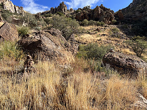
The only western access to Galiuro Wilderness by jacobemerick  Warning WarningAccess to the trailhead is limited, as it involves driving through private property. According to AZ Game & Fish, "The rancher usually unlocks the gate in October and then leaves it unlocked through about February. He does periodically lock it for holidays, usually Christmas and New Year's or the whole week between the two holidays. It is generally locked between March and September.". If the gate is unlocked, you need to sign up and display a pass, located at the first gate. Overview This trail is the only (reasonable) access to the Galiuro Wilderness trail system from the west, which could make it very appealing for backpackers in the Phoenix & Tucson areas looking to get to Powers Garden. It is tough yet surprisingly easy to follow, with more cairns along it than most of the trails in the wilderness.
Depending on the capabilities of your vehicle (see more info under Directions), either park or walk to the "trailhead" located a short distance within the wilderness area. There is a small spot here for 2-3 vehicles to park. There is no sign here -- the two-track continues east and becomes more overgrown. Follow this, and at 0.25 miles there is a fork, take the fainter option to the right and head down into YLE Canyon. Continue across the rocky creek floor and check out YLE Tank at the 0.5-mile mark. Tread picks up on the north side of the tank and stays on the east side of the unnamed tributary for a few hundred yards. After this, it hops from one bank to the other. There are a few competing game trails from cattle, and the catclaw sometimes eats up your route. If things get too annoying simply hop down into the rocky tributary bed and follow it upstream. Enjoy the shade and interesting rock formations along the way, because the climb does not offer many shade stops. There is a mesquite forest when you exit the creek at 2.2 miles. A few cairns mark a straight path through the forest, though you may want to circle around the greedy, spiky branches to avoid bloodshed (there's enough of that along the trail with all the catclaw). There's a brief hop back to the south side of the creek at 2.6 miles before the trail commits to the north side with a spicy climb. This trail tends to tackle the climbs directly, zipping up to a contour line before following it, seemingly avoiding the temptation to switchback. There are several cairns to help, some hidden by the long grass, others glaringly obvious. After circling the first cliff band (5600'), follow the cairns straight up to gain the ridge at 3.3 miles. This grassy ridge will make the next climb easier, as the hillside is particularly loose. You'll reach the saddle and start towards the second cliff band (6200'). This one is choked up by lots of brush, mostly manzanita, and the trail cuts a fairly direct line through it, with both cairns and flagging to mark the way. One final grassy climb after this and you're on top of Grassy Peak, 4 miles in. Enjoy the expansive views back to the west and the new views east - the Kielberg drainage is particularly fetching. There is also a pleasant campsite near the 'peak', if you have the water. The last stretch is flat, easy walking, with huge cairns partially obscured by tall grass and trees. Once you reach the W Divide Trail, you can either head south on your way to Rattlesnake or Powers Cabin, or you could head north and have a well-deserved water up at Powers Garden. Water Sources NONE worth mentioning. YLE Tank is near the trailhead and was not appealing when I checked in December 2023. The tributary is likely dry in all but the most wet of seasons. If you climbed up this trail, you'll probably want to drop down to Rattlesnake Canyon to refresh. Camping There are a few dry campsites along the climb, with the best one being at Grassy Peak itself. Gate Policy: If a gate is closed upon arrival, leave it closed after you go through. If it is open, leave it open. Leaving a closed gate open may put cattle in danger. Closing an open gate may cut them off from water. Please be respectful, leave gates as found. The exception is signage on the gate directing you otherwise. Check out the Official Route and Triplog. Leave No Trace and +Add a Triplog after your hike to support this local community. One-Way Notice This hike is listed as One-Way. When hiking several trails on a single "hike", log it with a generic name that describes the hike. Then link the trails traveled, check out the example. | ||||||||||||||||||||||||||||||||||||||||||||||||||||||||||||||||||||||||||||||||||||||


