username
X
password
register
for free!
help
 

Mesquite Canyon Trail - MSP, AZ

Guide 46 Triplogs  0 Topics
  2.2 of 5  
Fav
Wish
0
details
drive
no permit
forecast
route  
stats
photos
triplogs
topics
location
528 46 0
Statistics
tap row or icons for details
Difficulty 0.5 of 5
Route Finding 1 of 5
Distance One Way 0.24 miles
Trailhead Elevation 2,841 feet
Elevation Gain -19 feet
Accumulated Gain 20 feet
Avg Time One Way 10 minutes
Kokopelli Seeds 0.31
feature photo
Photos Viewed All MineFollowing
Will recalculate on button tap!
4  2024-02-07
Sven Towers 1-3 and MSP 38 of 39
pseudalpine
4  2024-01-19
Pemberton Trail - MMRP
trekkin_gecko
5  2024-01-19
Pemberton Trail - MMRP
johnlp
9  2023-10-14
Tom Lookout at the Eclipse
The_Eagle
5  2023-10-14
Tom Lookout at the Eclipse
Tortoise_Hiker
5  2023-06-10
Rock Knob Loop - MSP
BiFrost
6  2023-02-01
Toms Black Thumb - Search for Bob
The_Eagle
10  2021-02-26
Toms Thumb Super Duper Loop
DixieFlyer
Page 1,  2,  3,  4
Author
author avatar Guides 59
Routes 1,100
Photos 1,191
Trips 1,290 map ( 9,859 miles )
Age Male Gender
Location Arizona
Associated Areas
list map done
Phoenix Region
Historical Weather
Trailhead Forecast
Radar Map
Expand Map
Preferred Mar, Apr, Oct, Nov → 7 AM
Seasons   Autumn to Spring
Sun  6:03am - 6:49pm
Official Route & 1 Rt
 
14 Alternative


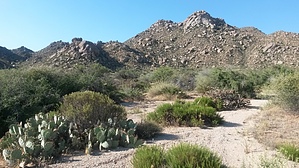
MSP Connector (TT1 - FS1)
by pseudalpine

Overview
Just one of the thirty-nine HAZ listed MSP trails, which specifically tracks northwest (TT1) to southeast (FS1) between the Tom's Thumb and Feldspar Trails. A previously dirt North 130th Street used to terminate near the southeast trail junction, where one once could park for hiking and climbing (mainly the Morrell's Wall areas) in the northern McDowell Mountains.


Hike
Demonstrably, this trail must be linked with other trails nearby, but the quickest approach to the northwest Mesquite Trail junction is a tenth of a mile north on the Tom's Thumb Trail from the Tom's Thumb TH. Overall, it's an uber mellow trail by MSP standards, most definitely fitting for disabled persons, the elderly, beginner hikers and young kids.
remove free decal offer

2024-02-08 pseudalpine
  • 2018 Southern Region
    area related
    2018 Southern Region
  • 2018 Gateway
    area related
    2018 Gateway
  • 2018 Tom's Thumb
    area related
    2018 Tom's Thumb


Check out the Official Route and Triplogs.
Leave No Trace and +Add a Triplog after your hike to support this local community.

One-Way Notice
This hike is listed as One-Way.

When hiking several trails on a single "hike", log it with a generic name that describes the hike. Then link the trails traveled, check out the example.
WARNING! Hiking and outdoor related sports can be dangerous. Be responsible and prepare for the trip. Study the area you are entering and plan accordingly. Dress for the current and unexpected weather changes. Take plenty of water. Never go alone. Make an itinerary with your plan(s), route(s), destination(s) and expected return time. Give your itinerary to trusted family and/or friends.

 Permit $$
None


 Directions
or
 Road
Paved - Car Okay

To Tom's Thumb Trailhead
1) 101 (Pima Freeway) to Frank Lloyd Wright
2) East on Frank Lloyd Right to N Thompson Peak Parkway
3) North on Thompson Peak Parkway to McDowell Sonoran Preserve Gateway Trailhead to drop off first vehicle
4) Then North on Thompson Peak Parkway to Pima Rd
5) North on Pima Rd to Happy Valley Rd
6) East on Happy Valley Rd until it turns north and changes to 116th st.
7) East on Ranch Gate Rd to 128th St
8) South on 128th to Park Entrance

From Exit 36 of AZ-101 Loop North, head northeast on North Pima Rd 4.7 miles to East Happy Valley Road. Turn right onto East Happy Valley Road and drive 4.3 miles to Ranch Gate Road. Turn right onto Ranch Gate Road and travel 1.3 miles and then turn right onto North 128th Street. After 1.0 mile on North 128th Street, you'll be at the trailhead gate. No water at the trailhead! Bathrooms are non-flush.

Warning
If you just pop in the coordinates of the trailhead, it's very possible that your GPS unit will tell you to wrong turn from Happy Valley Road onto Alameda Road at ( 33.706667, -111.832396 ). Don't do it! Those GPS units don't know that there's a locked gate at (33.694441, -111.813335).

From PHX (I-10 & AZ-51) 34.8 mi, 55 mins
From TUC (Jct 1-10 & Grant) 135 mi, 2 hours 24 mins
From FLG (Jct I-17 & I-40) 149 mi, 2 hours 37 mins
page created by joebartels on Feb 08 2024 5:24 pm
 90+° 8am - 6pm kills
helpcorrectionissue

end of page marker