 Route Editor

| Guide | ♦ | 50 Triplogs | 0 Topics |
details | drive | permit | forecast | 🔥 route |
stats |
photos | triplogs | topics | location |
| 628 | 50 | 0 |
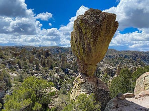
Prize of the Monument by markthurman53   CHIRICAHUA NATIONAL MONUMENT CHIRICAHUA NATIONAL MONUMENTChiricahua National Monument is on the north side of the Chiricahua Mountains in the Southeast corner of Arizona. About as far southeast as you can go in Arizona without being in New Mexico or Mexico. This is almost a fairy tale land of Rock spires, pinnacles, balanced rocks, and hoodoos where the laws of gravity don’t seem to apply. Although the park road traverses the park, to fully enjoy this park requires getting out of the car and hiking some of the 17 miles of trails. All the trails in the park are in excellent condition and well signed. This 12000-acre park was established on April 18, 1924, to preserve the park's natural wonders of weathered volcanic tuff. In 1934 during the great depression, the CCC built the park buildings, many of which still exist today. The many park trails throughout the park today were also constructed by the CCC. Before the monument's 1880s existence, the area was settled by ranchers and, prior to that, the Apaches. The monument has displays on the history, plants, and animals of this unique environment.
If you don’t mind the 2-hour drive from Tucson, Chiricahua Monument is a great place to visit and hike the scenic packed trails. This is relatively remote, so usually not crowded. The four or five times I have been there less than 50 visitors, and at least two of the times less than four cars in the park, and one of them was a park ranger (During the COVID thing). ECHO CANYON TRAIL Echo Canyon Trail has its upper trail head at the Echo Canyon Trail Head parking lot near the eastern end of the park road. This trail starts on top of the parks Rhyolitic Tuff pile and descends down Echo Canyon to its end point at the junction with the Upper Rhyolite Canyon Trail and the Hailstone Trail. This is probably the most impressive trail in the park, if not for its majestic rock formations, then for the great work the CCC put into making this trail. This trail drops over 600 feet as it descends Echo Canyon through a wonderland of rock crevices, Hoodoos, and spires and eventually ends up at Echo Park. Echo Park is one of the prettiest spots in the park; it is a small meadow along Echo Canyon covered in Apache Pine, Douglas-Fir and Arizona Cypress, a really nice place to take a break-even if you don’t need one. If you are heading up this trail it is a 600 foot 1.6 mile trail but you won’t notice the climb because around every corner is something interesting to see. I think they should of named this the Ooh Ahh Trail because you will hear that a lot as you hike along the trail. Check out the Official Route and Triplogs. Leave No Trace and +Add a Triplog after your hike to support this local community. One-Way Notice This hike is listed as One-Way. When hiking several trails on a single "hike", log it with a generic name that describes the hike. Then link the trails traveled, check out the example. | |||||||||||||||||||||||||||||||||||||||||||||||||||||||||||||||||||||||||||||||||||||||||||||||||||||||||||||||||||||||||||||||||||||||||||||||||||||||||||||||||||||||||||||||||||||||||||||||||||||||


