🔥

Mushroom Rock Trail, AZ

Guide 36 Triplogs Mine 0 0 Topics
 
3.7 of 5 
Fav
Wish
0
details
drive
permit
forecast
🔥
route  
stats
photos
triplogs
topics
location
309 36 0
Statistics
tap icons for details
Difficulty 2 of 5
Distance One Way 1.1 miles
Trailhead Elevation 6,424 feet
Elevation Gain 530 feet
Accumulated Gain 538 feet
Avg Time One Way 1 hour
Kokopelli Seeds 2.89
 Interest Seasonal Creek
 Backpack Possible - Not Popular
 Dogs not allowed
feature photo
Photos Viewed All MineFollowing
Will recalculate on button tap!
44  2022-07-02
Big Loop - Chiricahua National Monument
DarthStiller
28  2021-04-07
Echo Canyon Loop
markthurman53
2  2020-04-09
Big Loop - Chiricahua National Monument
toddak
29  2019-11-04
Big Loop - Chiricahua National Monument
BiFrost
7  2019-06-03
Big Loop - Chiricahua National Monument
LJW
38  2019-05-24
Chiricahua National Monument Trails Loop
markthurman53
23  2018-04-21
Big Loop - Chiricahua National Monument
Nightstalker
11  2016-05-26
Heart of Rocks Loop Trail
cactuscat
Page 1,  2,  3
Author
author avatar Guides 187
Routes 860
Photos 10,302
Trips 698 map ( 5,875 miles )
Age 69 Male Gender
Location Tucson, Arizona
Associated Areas
list map done
Tucson Region
Historical Weather
Trailhead Forecast
Radar Map
Expand Map
Preferred Oct, Nov, Mar, Apr
Seasons   Early Autumn to Late Spring
Sun  5:12am - 7:18pm
Official Route
 
17 Alternative
 
 Water
Historic Fire Perimeteracres
🔥 2011 Horseshoe 2 Fire158.9 mi*
Nearby Area Water
[ View More! ]
Fauna  Nearby
Geology  Nearby
Named place  Nearby
no photo labels yet
+Add > Photos to this Guide
then label as applicable
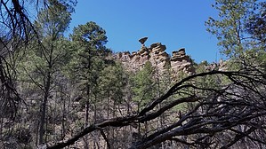
Look up or you'll miss it
by markthurman53

CHIRICAHUA NATIONAL MONUMENT

Chiricahua National Monument is on the north side of the Chiricahua Mountains in the Southeast corner of Arizona. About as far southeast as you can go in Arizona without being in New Mexico or Mexico. This is almost a fairy tale land of Rock spires, pinnacles, balanced rocks, and hoodoos where the laws of gravity don’t seem to apply. Although the park road traverses the park, to fully enjoy this park requires getting out of the car and hiking some of the 17 miles of trails. All the trails in the park are in excellent condition and well signed.This 12000-acre park was established on April 18, 1924, to preserve the park's natural wonders of weathered volcanic tuff. In 1934 during the great depression, the CCC built the park buildings, many of which still exist today. The many park trails throughout the park today were also constructed by the CCC. Before the monument's 1880s existence, the area was settled by ranchers and, prior to that, the Apaches. The monument has displays on the history, plants, and animals of this unique environment.

Geology-wise; when the Pacific Plate was being subducted under the west coast of the North American plate, Arizona was under compression, causing the Mesozoic and Paleozoic rocks to be folded and faulted and older layers were overriding younger. Once the pacific plate spreading ridge reached the North American plate, subduction ceased, and Arizona was now under extension or stretching forces creating an alternating system of mountains and valleys (Horst and Grabens). Early on in the extensional period of Arizona, large pools of molten rock formed under areas of Arizona, and this is where Chiricahua Mountains come in. In an eruption 1000 times greater than the Mount Saint Helen eruption, this magma erupted violently and formed what is known as the Turkey Creek Caldera, a crater 12 miles across. This crater is located in the Chiricahua Mountains in Turkey Creek and west of the Chiricahua ridgeline. The resulting explosion covered the monument with ash over 2000 feet thick, forming the Rhyolitic Tuff that now caps the park. Time and weathering formed the many bazaar rock formations now seen in the park.

If you don’t mind the 2-hour drive from Tucson, Chiricahua Monument is a great place to visit and hike the scenic packed trails. This is relatively remote, so usually not crowded. The four or five times I have been there less than 50 visitors, and at least two of the times less than four cars in the park, and one of them was a park ranger (During the COVID thing).


MUSHROOM TRAIL

Overview
The Mushroom Rock Trail connects the Ed Riggs Trail to the Big Balanced Rock Trail. This trail is the upper gateway to the Balanced Rock Trail, Inspiration Point, and the Heart of Rocks Loop. The trail follows along Hunt Canyon and climbs 530 feet over its 1.1-mile length. At about the midway point high up on the western walls of Hunt Canyon is Mushroom Rock; this rock formation looks like it defies all the laws of gravity. You have to be looking up, or you could miss it; I did the first time I hiked this trail. The Mushroom Rock Trail follows along the creek bed most of the way up Hunt Canyon until the very end, where it climbs out of the canyon and onto the mesa where it ends at the junction with the Balanced Rock Trail and Inspiration Point Trail.

Check out the Official Route and Triplogs.

Gate Policy: If a gate is closed upon arrival, leave it closed after you go through. If it is open, leave it open. Leaving a closed gate open may put cattle in danger. Closing an open gate may cut them off from water. Please be respectful, leave gates as found.

Leave No Trace and +Add a Triplog after your hike to support this local community.

2021-06-06 markthurman53

    One-Way Notice
    This hike is listed as One-Way.

    When hiking several trails on a single "hike", log it with a generic name that describes the hike. Then link the trails traveled, check out the example.
    WARNING! Hiking and outdoor related sports can be dangerous. Be responsible and prepare for the trip. Study the area you are entering and plan accordingly. Dress for the current and unexpected weather changes. Take plenty of water. Never go alone. Make an itinerary with your plan(s), route(s), destination(s) and expected return time. Give your itinerary to trusted family and/or friends.

     Permit $$
    National Monument Fee $10-25 per 7 Days

    Chiricahua National Monument
    Chiricahua NM $5 per person / 7 Day Entrance Fee


     Directions
    or
    or
     Road
    Connector trail - Not Applicable

    To hike
    From Interstate 10 at Wilcox, take AZ186 south about 34 miles. Take AZ181 east 3 miles to the Monument entrance. Access from the south at Douglas is along AZ186 north and AZ 181, about 60 miles. Access from the east is over a long dirt road over the Chiricahua Mountains through Portal Arizona. This eastern route is not recommended as the road may be impassable during bad weather or winter snow.
    page created by joebartels on Jun 06 2021 11:29 am
     90+° 8am - 6pm kills
    helpcorrectionissue

    end of page marker