one thousand tons proportionally weighted by markthurman53
CHIRICAHUA NATIONAL MONUMENT
Chiricahua National Monument is on the north side of the Chiricahua Mountains in the Southeast corner of Arizona. About as far southeast as you can go in Arizona without being in New Mexico or Mexico. This is almost a fairy tale land of Rock spires, pinnacles, balanced rocks, and hoodoos where the laws of gravity don’t seem to apply. Although the park road traverses the park, to fully enjoy this park requires getting out of the car and hiking some of the 17 miles of trails. All the trails in the park are in excellent condition and well signed.
This 12000-acre park was established on April 18, 1924, to preserve the park's natural wonders of weathered volcanic tuff. In 1934 during the great depression, the CCC built the park buildings, many of which still exist today. The many park trails throughout the park today were also constructed by the CCC. Before the monument's 1880s existence, the area was settled by ranchers and, prior to that, the Apaches. The monument has displays on the history, plants, and animals of this unique environment.
Geology-wise; when the Pacific Plate was being subducted under the west coast of the North American plate, Arizona was under compression, causing the Mesozoic and Paleozoic rocks to be folded and faulted and older layers were overriding younger. Once the pacific plate spreading ridge reached the North American plate, subduction ceased, and Arizona was now under extension or stretching forces creating an alternating system of mountains and valleys (Horst and Grabens). Early on in the extensional period of Arizona, large pools of molten rock formed under areas of Arizona, and this is where Chiricahua Mountains come in. In an eruption 1000 times greater than the Mount Saint Helen eruption, this magma erupted violently and formed what is known as the Turkey Creek Caldera, a crater 12 miles across. This crater is located in the Chiricahua Mountains in Turkey Creek and west of the Chiricahua ridgeline. The resulting explosion covered the monument with ash over 2000 feet thick, forming the Rhyolitic Tuff that now caps the park. Time and weathering formed the many bazaar rock formations now seen in the park.
If you don’t mind the 2-hour drive from Tucson, Chiricahua Monument is a great place to visit and hike the scenic packed trails. This is relatively remote, so usually not crowded. The four or five times I have been there less than 50 visitors, and at least two of the times less than four cars in the park, and one of them was a park ranger (During the COVID thing).
BIG BALANCED ROCK TRAIL
Overview
The Big Balanced rock trail has no accessible trailhead except east via the Mushroom Rock Trail and west via the Sarah Deming Trail. This 1-mile trail follows along the southern mesa of Chiricahua National Monument and is fairly level with only 250 feet of elevation change. Along with great views of the Chiricahua Mountains to the south, there are quite a few interesting rock formations along the way and culminates on the west end at the Big Balanced Rock, another rock that appears to defy gravity. There are also great views over the area that the heart of Rocks trail covers. The Balanced Rock Trail ends at the Heart of Rocks Trail junction and the Sarah Deming Trail. There is minimal cover from trees along this trail, mainly shrubs and a few junipers. Side trips from this trail are the Inspiration Point Trail and the Heart of Rocks Trail, both of which are worth the time and effort to see.
When hiking several trails on a single "hike", log it with a generic name that describes the hike. Then link the trails traveled, check out the example.
WARNING! Hiking and outdoor related sports can be dangerous. Be responsible and prepare for the trip. Study the area you are entering and plan accordingly. Dress for the current and unexpected weather changes. Take plenty of water. Never go alone. Make an itinerary with your plan(s), route(s), destination(s) and expected return time. Give your itinerary to trusted family and/or friends.
Permit $$
National Monument Fee $10-25 per 7 Days
Chiricahua National Monument Chiricahua NM $5 per person / 7 Day Entrance Fee
Directions
Road
Connector trail - Not Applicable
To hike From Interstate 10 at Wilcox, take AZ186 south about 34 miles. Take AZ181 east 3 miles to the Monument entrance. Access from the south at Douglas is along AZ186 north and AZ 181, about 60 miles. Access from the east is over a long dirt road over the Chiricahua Mountains through Portal Arizona. This eastern route is not recommended as the road may be impassable during bad weather or winter snow.
page created by joebartels on Jun 06 2021 11:51 am
 Route Editor


 CHIRICAHUA NATIONAL MONUMENT
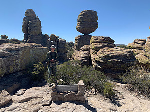


