Route Editor

| Guide | ♦ | 11 Triplogs | 0 Topics |
details | drive | no permit | forecast | 🔥 route |
stats |
photos | triplogs | topics | location |
| 134 | 11 | 0 |
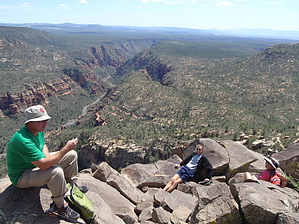
Not-so-bad, Large Sedona Loop by AZOutdoorsman   Thought this would be a good, somewhat close, training hike for bigger Grand Canyon hikes. Couldn't find much info on doing Hot Loop Trail #94 with Jack's Canyon Trail #55 as a loop. Most had only done the lower section of Hot Loop and turned back before getting too far in, missing the better upper section and then discounting the trail. Also, not much info on the last section up on the plateau, and no trail is listed on most maps. So, after successfully completing the loop I thought I would share the info, as I know there are some big-loop hikers on this site. The route finding and trail conditions were not bad at all, nothing like I was expecting - there were also many cairns and several signs. Thought this would be a good, somewhat close, training hike for bigger Grand Canyon hikes. Couldn't find much info on doing Hot Loop Trail #94 with Jack's Canyon Trail #55 as a loop. Most had only done the lower section of Hot Loop and turned back before getting too far in, missing the better upper section and then discounting the trail. Also, not much info on the last section up on the plateau, and no trail is listed on most maps. So, after successfully completing the loop I thought I would share the info, as I know there are some big-loop hikers on this site. The route finding and trail conditions were not bad at all, nothing like I was expecting - there were also many cairns and several signs.From the Jacks Canyon TH on the outskirts of the Village Of Oak Creek head out on the Hot Loop trail. The trail is well-defined and mostly soft dirt through this section after about 1.2 miles the trail crosses the major drainage and just after turns up on a well-defined trail. There isn't a sign at this junction, just after the trail Vs sharply, if you miss the turn you end up at Woods Canyon. Now you are ascending up onto Horse Mesa passing Hot Loop Tank along the way. Once on the mesa, the trail has a split coming off to the left and right, stay straight on the main trail.
Coming off the north end of the mesa you descend a bit and cross some small tributary drainages before ascending to the plateau. Just before the top, there is a section of encroaching oak brush that can give some scratches - not too bad, and I was in shorts. At the top, there's a cool place to hang in the boulders with a view while waiting for others to make it out. The plateau portion of the Hot Loop Trail is well defined (in dry conditions), cairned, and signed. Just before reaching Jack's Canyon Trail #55 Schnebly Hill Trail #158 enters from the north. At the top of Jacks Canyon, you can head down its trail and continue the loop. But... for extended play and added bonus, I highly recommend continuing up to Munds Mountain Trail #77 for spectacular view to the north and west to some of Sedona's classic red rock formations. This out-and-back option adds another mile and 500' EC to the posted stats (making the loop 21M/3,600' AEC). As soon as you get up on top the terrain opens and just walk off-trail toward NW corner - maybe 100 yards? After the views head back down and catch the Jacks Canyon trail for the return back to the TH. This trail is pretty straightforward and detailed on its guide page. Definitely not the best two trails in the Sedona area, but once you get away from the houses near the TH, it has a wilderness feel and no other hikers on the Saturday in mid-April when we were there. Completed with a group of strong hikers in 9 hours. If you are looking for a big hike and something new give it a look. I may never do it again ???, but glad I came. Enjoy! Peace : )
Check out the Official Route and Triplogs. Note This is a moderately difficult hike. Leave No Trace and +Add a Triplog after your hike to support this local community. | ||||||||||||||||||||||||||||||||||||||||||||||||||||||||||||||||||||||||||||||||||||||||||||