 Route Editor

| Guide | ♦ | 17 Triplogs | 0 Topics |
details | drive | permit | forecast | route |
stats |
photos | triplogs | topics | location |
| 121 | 17 | 0 |
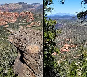
Schnebly me boy! by HAZ_Hikebot   The Schnebly Hill Trail climbs moderately and steadily up the west face of Schnebly Hill following the original alignment of Schnebly Hill Road. There are some magnificent red rock views for the first 0.75 miles, which is unshaded. The trail enters partial shade and at 1.25 miles, where the roadbed turns sharply to the left, take the trail on the right, which is signed "Munds, Jacks, Hot Loop." It climbs moderately in the shade for nearly 0.75 miles, passing through 2 cattle gates, and emerging on a large, open expanse near Committee Tank. The Schnebly Hill Trail climbs moderately and steadily up the west face of Schnebly Hill following the original alignment of Schnebly Hill Road. There are some magnificent red rock views for the first 0.75 miles, which is unshaded. The trail enters partial shade and at 1.25 miles, where the roadbed turns sharply to the left, take the trail on the right, which is signed "Munds, Jacks, Hot Loop." It climbs moderately in the shade for nearly 0.75 miles, passing through 2 cattle gates, and emerging on a large, open expanse near Committee Tank.Several overlooks offer great views of Munds Mountain, Bear Wallow Canyon, and the red rock formations beyond. The trail is level for the next quarter-mile and then descends to a saddle separating Schnebly Hill and Munds Mountain at the head of Jacks' Canyon. More nice views. Just before reaching the saddle, there is a signed trailhead on the left for Hot Loop. Continue down another 150 yards where there are two more signed trailheads. The Jacks Canyon Trail leads down to the left.
Gate Policy: If a gate is closed upon arrival, leave it closed after you go through. If it is open, leave it open. Leaving a closed gate open may put cattle in danger. Closing an open gate may cut them off from water. Please be respectful, leave gates as found. The exception is signage on the gate directing you otherwise.
Check out the Official Route and Triplogs. Leave No Trace and +Add a Triplog after your hike to support this local community. One-Way Notice This hike is listed as One-Way. When hiking several trails on a single "hike", log it with a generic name that describes the hike. Then link the trails traveled, check out the example. | ||||||||||||||||||||||||||||||||||||||||||||||||||||||||||||||||||||||||||||||||||||||||||||||||||||||||||||||||||||||||||||||||||||||||||||||||||||||||||||||||||||||||||||||||||||


