username
X
password
register
for free!
help
 This is likely a great time to hike this trail!  Check out "Preferred" months below, keep in mind this is an estimate.
  🔥

Mt Baldy Crossover Trail, AZ

Guide 40 Triplogs  1 Topic
  3.5 of 5  
Fav
Wish
1
details
drive
no permit
forecast
🔥
route  
stats
photos
triplogs
topic
location
561 40 1
Statistics
tap row or icons for details
Difficulty 1.5 of 5
Route Finding 1 of 5
Distance One Way 3.17 miles
Trailhead Elevation 9,400 feet
Elevation Gain 204 feet
Accumulated Gain 484 feet
Avg Time One Way 1.5 hours
Kokopelli Seeds 4.78
 Interest Seasonal Creek & Perennial Creek
feature photo
Photos Viewed All MineFollowing
Will recalculate on button tap!
14  2024-09-21
Mount Baldy Loop
mikemcg
15  2023-10-31
Mount Baldy Loop
GrangerGuy
8  2023-10-21
Mount Baldy Loop
emilystardust
10  2023-09-26 kingsnake
20  2023-09-23
Mount Baldy Loop
The_Eagle
18  2023-09-23
Mount Baldy Loop
johnlp
13  2023-09-23
Mount Baldy Loop
trekkin_gecko
33  2021-08-06
White Mountains Tour
andrewp
Page 1,  2,  3,  4,  5
Author
author avatar Guides 116
Routes 337
Photos 11,399
Trips 894 map ( 8,139 miles )
Age 63 Male Gender
Location Sunnyslope, PHX
Associated Areas
list map done
Alpine Region
Historical Weather
Trailhead Forecast
Radar Map
Expand Map
Preferred Jun, Jul, Aug, Sep → 7 AM
Sun  5:54am - 6:40pm
Official Route & 1 Rt
 
20 Alternative
 
Historic Fire Perimeteracres
🔥 2011 Wallow Fire29


over the river and through the woods
by kingsnake

 Likely In-Season!
Described south-to-north:
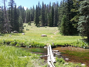
From East Baldy Trailhead, head west on the wide gravel East Baldy Trail #95. In 300 yards, Crossover Trail is on the right.


In a little over three miles, the trail makes three short, but steep, climbs: 180 ft. at 8%, 100 ft. at 10%, and 160 ft. at 12%. If you are not acclimated to the elevation, you will feel it on the climbs. The hills are heavily forested with mixed ponderosa pine, spruce, Douglas-fir and aspen. Even in forests, this kind of deep shade is rare in Arizona. The highest-elevation lake in Arizona, 35-acre Lee Valley Lake, may be visible through the trees.
remove free decal offer
In between the three hills are grassy cienegas. The first is nearly a half-mile wide and drains into Lee Valley Lake. (As does the second cienega.) The other cienegas are much smaller. Any creeks are easy to cross dry.

Descending to West Fork Little Colorado River, the trail is steep enough to have switchbacks.

The trail terminates and ends just across the LCR. Turn right (east) on West Baldy Trail #94. It is a little over a mile to the trailhead.

By itself, the trail is 3.17 miles but hiked from trailhead to trailhead, it is 4.6 miles.

2023-09-28 kingsnake


    Check out the Official Route and Triplogs.
    Leave No Trace and +Add a Triplog after your hike to support this local community.

    One-Way Notice
    This hike is listed as One-Way.

    When hiking several trails on a single "hike", log it with a generic name that describes the hike. Then link the trails traveled, check out the example.
    WARNING! Hiking and outdoor related sports can be dangerous. Be responsible and prepare for the trip. Study the area you are entering and plan accordingly. Dress for the current and unexpected weather changes. Take plenty of water. Never go alone. Make an itinerary with your plan(s), route(s), destination(s) and expected return time. Give your itinerary to trusted family and/or friends.

     Permit $$
    no fees or permits reported

    if incorrect tell us about it


     Directions
    or
     Road
    Paved - Car Okay

    To hike
    page created by joebartels on Apr 21 2013 12:08 pm
     90+° 8am - 6pm kills
    helpcorrectionissue

    end of page marker