 Route Editor

| Guide | ♦ | 4 Triplogs | 0 Topics |
details | drive | permit | forecast | 🔥 route |
stats |
photos | triplogs | topics | location |
| 32 | 4 | 0 |
obscure peak by Mountain_Rat  Most who take the Finger Rock Trail have one of two goals in mind; Mt. Kimball and back, or the Finger Rock - Pima Canyon Traverse. It would seem that few know of this obscure peak, a mere 0.3 miles from the Finger Rock/ Pima Canyon junction. In fact, the register at the peak has recorded only seven visits in its four years of service. (This may be due to the shortage of paper and pencils at the peak. Keep that in mind if you drop pack at the saddle below). Most who take the Finger Rock Trail have one of two goals in mind; Mt. Kimball and back, or the Finger Rock - Pima Canyon Traverse. It would seem that few know of this obscure peak, a mere 0.3 miles from the Finger Rock/ Pima Canyon junction. In fact, the register at the peak has recorded only seven visits in its four years of service. (This may be due to the shortage of paper and pencils at the peak. Keep that in mind if you drop pack at the saddle below).Your excursion begins at a combined trailhead which includes the Pontatoc Canyon, Pontatoc Ridge, and of course, the Finger Rock Trail #42 (Take the #42, obviously). The first mile you'll be thinking "this is not as bad as people make it out to be". At 1.2 miles you will have changed your tune, as you've begun a 26%, uphill grade for the next three miles, without relief. All of this is made more than acceptable by the ever-present views ahead that just keep drawing you in.
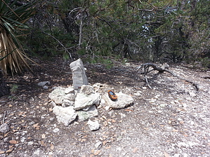
You'll certainly know when you've reached the peak. It is the obvious high point, with a tiny clearing, and a stone shrine that houses an olive jar, registry. The precise peak offers no views as it is wooded over, but wanderings of its circumference will. Don't forget to bring your own pen and paper if you wish to join the official list of visitors here. Check out the Official Route and Triplogs. Note This is a moderately difficult hike. Leave No Trace and +Add a Triplog after your hike to support this local community. One-Way Notice This hike is listed as One-Way. When hiking several trails on a single "hike", log it with a generic name that describes the hike. Then link the trails traveled, check out the example. | |||||||||||||||||||||||||||||||||||||||||||||||||||||||||||||||||||||||||||||||||||||||||||||||||||||||||||||||||||||||


