 Route Editor

| Guide | ♦ | 24 Triplogs | 1 Topic |
details | drive | permit | forecast | 🔥 route |
stats |
photos | triplogs | topic | location |
| 140 | 24 | 1 |
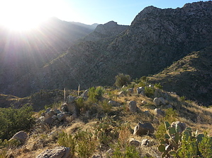
Bust a loop by Mountain_Rat  Overview OverviewThis journey expounds on the already excellent Buster Mountain description, as they share the same primary goal in bagging Buster Mountain with all of its views. This version differs, though, as it’s not only a scenic tour but a historical one as well. History Though details are slim, the history of this immediate area seems to revolve around the late Buster Bailey. Buster moved here from Texas in 1927. His father built their home somewhere in the area that is now Catalina State Park. Buster’s family soon moved back to Texas, but Buster returned to his one true love, The Catalina Mountains. He worked for area ranchers, he worked for the Zimmerman family, who developed what is now Summer Haven on Mt. Lemmon, but Buster’s real claim to fame was as a bootlegger, operating his still near the waters of the now dry Buster Spring. Remnants of his still are said to be in place, though in disrepair, somewhere near the current spring. This was Buster’s stomping ground, and you can’t help but feel connected to him while you’re here. It’s said that he packed his product down alternating routes so as not to leave any obvious trails. It would be safe to say that if you’re on any passable route in or around Buster Canyon, Buster himself had been there.
From the trailhead at Catalina State Park, cross the Sutherland Wash. As you come out of the wash, turn right (south) to the Birding Trail. At about 1/4 mile in, you'll come to a fork where you can either go straight (south) or turn off to your right (west). Go straight and continue a short way, crossing the Montrose stream bed where you'll come to another fork. A 'No Horses' sign marks this fork. You'll be returning this way on the right trail, but for the approach, veer left, about 15 paces, until you see a faint trail, crossing a tiny wash. You should now be facing east. This is the trail that takes you up the ridge. Break out the camera and cruise. You won't believe the views that develop as you go. For the next 1.7 miles, this trail is clear and well cairned. Once you top the ridge at Hill 4223, however, the trail vanishes into the grasses. Not to worry, as the remainder of your journey is all within view and holds no surprises. This is truly one of the most simple bushwhacks ever. From here, your path to the peak is clear. Pass south, down through the saddle in front of you. As you start up the other side, there will be a rocky knoll. Look for a vague side trail leading east to Buster Spring, should you care to visit it. From this point, look southwest to the saddle below Buster, climb gradually as you contour the hill in front of you, counter-clockwise to meet the saddle on the other side. It will just make sense once you're there looking at it. Now make the short climb west to bag the peak, which includes views that can only be captured here. This is the one spot that sums up the magnitude of Pusch Ridge above. Buster Mountain is a not-so-well-known peak, just inside the northwest boundary of the Pusch Ridge Wilderness. Its anonymity is largely due to the fact that it seems a dwarf compared to the walls of Pusch Ridge, towering above. However, anyone who has visited Buster would have to agree that it’s no dwarf but something of a beast. Of its many attractive aspects, Buster is best known as the prime vantage point from which to view Pusch Ridge and Alamo Canyon. For your return, take a short stroll across the small saddle southwest of the peak, keeping your eyes peeled for a hint of trail or a cairn that will mark the beginning of your descent. The trail is very spotty but decently cairned as it guides you northwest, down the ridge. At about 1/3 of a mile, you’ll encounter a small downclimb. This would be nothing to the average rock climber, but it's exciting to a trail guy like me. The further along you go, the more defined the trail becomes until suddenly it mellows into smooth sailing about 1.1 miles from the peak. The remaining 1.2 miles will be rather uneventful unless you turn around now and then to admire what you’ve accomplished. Just a note; I’ve written this guide as a clockwise loop, as it is much more dramatic scenery-wise than the reverse. Check out the Official Route and Triplogs. Leave No Trace and +Add a Triplog after your hike to support this local community. | |||||||||||||||||||||||||||||||||||||||||||||||||||||||||||||||||||||||||||||||||||||||||||||||||||||||||||||||||||||


