 Route Editor

| Guide | ♦ | 6 Triplogs | 0 Topics |
details | drive | permit | forecast | map |
stats |
photos | triplogs | topics | location |
| 31 | 6 | 0 |
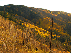
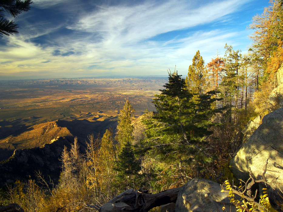
dress warm, don't go blair-ashed by PrestonSands  Overview OverviewThis hike takes in some of the Pinaleno Mountains' finest scenery by using the popular Ash Creek and Webb Peak Trails and an off-trail excursion along Blair-Ash Ridge. The off-trail section roughly follows a long-vanished logging road, once known as trail #344, past what I call Tramway Peak. In addition to the loop hike, there is the option for a side trip to the summit of 10,030 foot Webb Peak or picturesque Ash Creek Falls. Hiking distance on this loop will vary between 5.3 and 6 miles (not including any side trips), depending on your descent route from Blair-Ash Ridge to the Ash Creek Trail. State highway 366, which provides access to this hike, is closed yearly due to snow from November 15 through April 15 (or possibly later), about 6.7 miles before the trailhead.
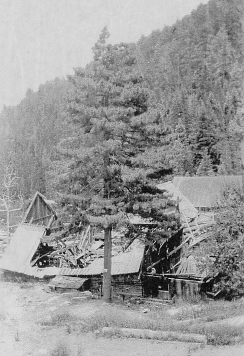
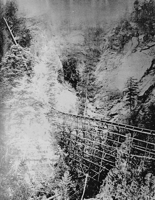
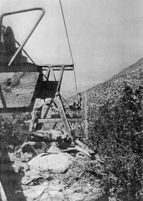
Route finding skills and a topographical map of the area are essential for this hike. There are some exposed spots along Blair-Ash Ridge, so be sure to get an early start to avoid lightning during monsoon season. History In the early twentieth century, the Pinaleno Mountains were an important source of lumber for southeastern Arizona. However, transporting the lumber off the top of the range was a major obstacle due to the exceptionally rugged topography. The Mount Graham Lumber Company sawmill, located along upper Ash Creek, constructed a flume down Ash Creek Canyon in 1907 to slide its product a vertical mile down to the valley below. Problems plagued the flume however, so the mill owners replaced it with an aerial tramway in 1923. Operating somewhat like a ski lift, lumber was lifted out of Ash Creek canyon and up to Blair-Ash Ridge, where it began a long drop to an unloading station on the desert floor below. As logging waned in the following decades, the sawmill and tramway were removed. A few logging relics and evidence of the tramway are still visible in the area. Hike At the Ash Creek Trailhead, head down the Ash Creek Trail #307. This trail makes a switchback descent through tall aspens to Ash Creek and then follows the heavily wooded east wall of the canyon. At 0.6 miles, the Ash Creek Trail reaches a signed junction with the Webb Peak Trail #345, next to a rusted boiler dating from the area's logging days. Turn left (north) onto the Webb Peak Trail. After a straight stretch along this former logging road, the Webb Peak Trail rounds a ridge and turns southwest. However, if you continue northeast for a short way along the point of the ridge, there is a great view down Ash Creek Canyon from a rocky knoll (32.71745 N, 109.91045 W). Continuing, the Webb Peak Trail heads west along the north slope of Webb Peak, then turns north again after crossing a tributary of Ash Creek. The Webb Peak Trail reaches Blair-Ash Ridge at 1.5 miles, where it makes a switchback to the southwest to continue up the ridge to Webb Peak. This hike, however, leaves the Webb Peak Trail behind at the ridge (32.72005 N, 109.91621 W) and heads northeast along its broad crest into dense and tangled timber. Stay high on the ridge, heading north. You may come across rusted cables and other evidence of historical logging. At 2 miles, the forest parts to reveal the grassy summit of peak 9516' (Tramway Peak, 32.72513 N, 109.91489 W). From the summit, there are dramatic views in all directions. From the peak, continue east, again staying high on the ridgeline, as the route makes a steady descent through second-growth forest. The ridge becomes more of a slope around mile 2.5 and angles northeast into a broad, sloping fern meadow (32.72658 N, 109.90686 W). Watch your footing in the meadow. Just below the meadow, the route arrives at a broad saddle, on the east side of which is point 9031'. Climb the rocky little point for another sweet view of the area. At the broad saddle, trail #344 reappears as an eroded wagon trail descending to the east along the south slope of the ridge and is shown on the USGS Webb Peak topo map. At this point, you can either head directly downslope to the Ash Creek Detour Trail #307A or follow trail #344 east for a half-mile to where it meets the Ash Creek Detour Trail #307A. Once you reach the narrow path of the Detour, which bypasses Slick Rock and roughly contours along the 8600-foot level, you can turn left or right. Either way will deposit you onto the Ash Creek Trail #307, where this is the option for a side trip to Ash Creek Falls (consult a topo map). To complete the hike, head upstream (south) along the Ash Creek Trail #307 as it travels along the narrow and heavily wooded canyon bottom. The large meadow at the 8700-foot level is the former location of the Mount Graham Lumber Company sawmill. The Ash Creek Trail leaves the meadow on its south side and crosses Ash Creek, before beginning a 1.3-mile climb out of the canyon, past the Webb Peak Trail junction, and back to the Ash Creek Trailhead. Check out the Triplogs. Leave No Trace and +Add a Triplog after your hike to support this local community. | ||||||||||||||||||||||||||||||||||||||||||||||||||||||||||||||||||||||||||||||||||||||||||||||


