Route Editor

| Guide | ♦ | 5 Triplogs | 0 Topics |
details | drive | permit | forecast | route |
stats |
photos | triplogs | topics | location |
| 10 | 5 | 0 |
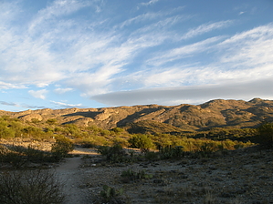
Gateway to the southeastern Rincons by Jeffshadows   Background BackgroundThe out-of-service Madrona Ranger Station in Mica Mountain's southeastern foothills is the site of a series of majestic pools and the former trailhead for remote trails which now simply come together there. It is also the flash point of contention over access issues in the Tucson valley that still rage today between developers and conservationists. Madrona was commissioned and developed in the 1940-60s in the image of Sabino Canyon to be a destination for picnicking and a trailhead site for Saguaro National Park, primarily due to its proximity to the perennial pools in Chiminea canyon to the west. The Rincon Creek and Manning Camp trails traditionally departed here; both of which are now relatively difficult to access. The trail that left here was once the most direct route into Manning Camp. Until 1968, the NPS continued to improve the area, adding stables and other comforts for users. Monthly narratives from the Superintendent of the Park always included visitation, temperature, and usage data for Madrona during this period signaling that Madrona was a key element of the Park. The Park Service also used the area to stable horses to supply Manning and supplies for fire suppression.
Subsequently, Park officials were supplied with keys, and, in the years that followed, the Park began negotiations to purchase the easement into Madrona from Colossal Cave road. These negotiations never gained traction and the area remained closed to public access, reportedly due to a covert deal between Jackson and a Park Superintendent to prevent access from ever being reattained. The situation was complicated further in the 1980s when a development group purchased the X-9 ranch and subdivided it into 36 private parcels for luxury homes. Due to access restrictions, the Ranger Station was manned only sporadically, and the area fell into disrepair, ultimately succumbing to a mouse infestation and outbreak of Hantavirus. The NPS effectively closed the Ranger Station after the outbreak. Homeowners in the X-9 Ranch area are obstinate about not ever providing access to Madrona, despite their acknowledged personal use of the area and increased pressure from groups like the Arizona Trail Association who want access restored for public use. A survey undertaken by researchers at the University of Arizona found that 80% of residents and 70% of non-residents felt strongly that access to Madrona should be restored. Author's Note: The NPS will tell anyone who asks that the route described herein is not authorized or endorsed in any way and travel on Parkland requires a fee. It is also necessary to cross AZ State Trust Land to complete this hike, so visitors should ensure they have a valid State Land Use permit; or valid AZ hunting or fishing license. Hike Both the Hope Camp and North Hope Camp trails have great descriptions available on HAZ so there's no need to provide another here. Continue from the Loma Alta trailhead to the end of the North Hope Camp spur trail. Where North Hope ends a faded, vertical "Trail Closed" stake is present; continue beyond this stake heading 24 degrees northeast. There is a well-worn track present leading onto the hillside above toward a barbed-wire fence. This is the State Trust Land boundary. Cross onto State Trust land where this track meets the fence and continue downhill via what remains of the track as it disappears into the side drainage you are now following. From this point, on, the objective is to reach an old jeep trail roughly 1.7 miles to the east. There is no defined trail through this section of the hike, but one can be formulated out of a complex of game trails and side drainages which will allow you to avoid the rougher bushwhacking that might otherwise be necessary. The best way to keep to these trails and drainages is to maintain movement bearing on Rincon Peak with the park boundary 200 meters to the north throughout the trip. Large cairns were left at most of the major drainage and wash crossings in November of 2008. After passing through the first wash, ascend the second hill using another side drainage. Drop down into a second, larger wash after the second hill and ascend the ridge on the opposite bank by way of a well-defined game trail. After ascending out of the wash, continue overland using a faint stock trail. This area is completely exposed. The game trail will disappear and become a drainage dropping into a third wash. Cross the third wash and ascend the third hill. Once atop the third hill, the NPS boundary will become visible below, above a major wash. Continue along a game trail toward the fence. Cross back into the Park and continue through the major wash, which is populated by a mesquite bosque. Follow a faint game trail that leaves the wash by means of a small rock outcropping on the eastern bank and ascend the fourth hill. The game trail disappears and it becomes necessary to bushwhack through a drainage ascending its west side. Once the top of the fourth hill is attained, the old jeep trail is visible on a ridge line to the east. Look for a line of grass that seems out of place along a ridge that appears to be leaving the area just north of Sentinel Butte and running north to Mica Mountain. Continue across the small plain here heading 30 degrees east, cross the fifth drainage, and over two small rolling hills until a large drainage is met. At the bottom of this drainage is the State Trust Land boundary fence. Cross this large drainage where the granite bedrock is exposed and ascend the fifth large hill. Once the top of the fifth hill is attained, walk a few meters east and the old jeep trail will appear; a large cairn marks this spot. Take the old jeep trail due northeast into the Mica Mountain foothills; following its course for an additional 1.3 miles until an overhead power line is met. The track of the jeep trail is wide and easy to follow, though overgrown with tall grass. If the route of the old road is ever in question just look for the rocks lining the sides of the road left over from a grating the road received decades back. Upon arrival at the power line, turn almost due north and follow the track that lies just below and to the right of the power line. This appears to be an old maintenance road for the utilities that once served the Madrona station before it was closed. Do not take the tracks that go south or east from this point. Before long, the road turns sharply to the west to a large water tank. Follow a path that leaves the maintenance road and follows below and 50 meters to the east of the power lines. The path drops into a drainage and meets the NPS boundary, once again. A gate has been constructed here in between two railroad ties. Pass through this gate and follow a path that leads left as the power line breaks right and crosses over a deep wash. Madrona is now visible on the far bank of the wash. The path meets a weak point along the bank of the wash where rocks allow one to descend into the wash. This area is the renowned Madrona Pools area. Continue up-wash for roughly 50 meters until the Manning Camp trail is encountered where it crosses the wash. Follow the Manning Camp trail east into the Madrona Ranger Station. There is a memorial to an NPS trail crew member to the left of the trail and several buildings ahead at the site. A series of park benches are situated atop a hill over the stables which provide a nice view of Rincon Peak. Observe the warnings about accessing the buildings as there is a distinct disease hazard present. Return to the North Hope Camp trail by the same route. Gate Policy: If a gate is closed upon arrival, leave it closed after you go through. If it is open, leave it open. Leaving a closed gate open may put cattle in danger. Closing an open gate may cut them off from water. Please be respectful, leave gates as found. The exception is signage on the gate directing you otherwise.
Check out the Official Route and Triplogs. Leave No Trace and +Add a Triplog after your hike to support this local community. | ||||||||||||||||||||||||||||||||||||||||||||||||||||||||||||||||||||||||||||||||||||||||||||||||