Whiskey Bottle Trail - MSPN, AZ | HikeArizona
username
X
password
register
for free!
help
 This is likely a great time to hike this trail!  Check out "Preferred" months below, keep in mind this is an estimate.
 

Whiskey Bottle Trail - MSPN, AZ

Guide 75 Triplogs  0 Topics
  2.9 of 5 
Fav
Wish
0
details
drive
no permit
forecast
route  
stats
photos
triplogs
topics
location
52 75 0
Statistics
tap icons for details
Difficulty 1 of 5
Route Finding 1 of 5
Distance One Way 2.9 miles
Trailhead Elevation 2,522 feet
Elevation Gain 210 feet
Accumulated Gain 300 feet
Avg Time One Way 1 hour
Kokopelli Seeds 3.9
unreported if dogs are allowed
editedit > ops > dogs to adjust
feature photo
Photos Viewed All MineFollowing
Inaugural Calculation on Button Tap!
7  2022-11-27
Cholla & Fraesfield
trekkin_gecko
7  2022-11-27
Cholla & Fraesfield
johnlp
45  2022-03-17
McDowell Sonoran Preserve Southeastern Loop
tibber
10  2021-12-18
Granite Mountain Loop Trail - MSPN
DarthStiller
4  2021-11-13
Fraesfield Loop
Nightstalker
3  2021-01-28
Black Hill Trail - MSPN
mazatzal
1  2020-01-22
Whiskey Bottle Loop - MSPN
mazatzal
8  2020-01-05
Jane Rau Interpretive Trail - MSPN
DarthStiller
Page 1,  2,  3,  4,  5,  6
Author
author avatar Guides 27
Routes 460
Photos 8,745
Trips 652 map ( 5,936 miles )
Age 53 Male Gender
Location Mesa, AZ
Associated Areas
list map done
Phoenix Region
Historical Weather
Trailhead Forecast
Radar Map
Expand Map
Preferred Feb, Jan, Dec, Mar
Seasons   Autumn
Sun  6:56am - 6:24pm
Official Route
 
16 Alternative
 
 Water


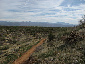
quickest trail to the center of the northern expansion
by DarthStiller

 Likely In-Season!
The Whiskey Bottle Trail is a new trail in the expanded northern section of the McDowell Sonoran Preserve. The trail starts at the Fraesfield Trailhead and heads northwest across the northeast side of Fraesfield Mountain and terminates at Powerline Road #2. From there, you can go back the way you came, or continue throughout the system of trails making a larger loop back to the Fraesfield Trailhead.


Take the wide dirt road from the trailhead north, which is the Black Hill Trail. At 0.1 miles, the junction for the Whiskey Bottle is also at the same point as the Monument Trail. Take the Whiskey Bottle Trail to the left and head northwest. The trail very quickly becomes a narrow single track and begins to gain elevation along the northeast side of Fraesfield Mountain. Below you to your right, you can see the Black Hill Trail head directly north, as well as the Dixileta Trail that junctions with it. Behind you are very good views of Four Peaks and to your right the Mazatzals and Mt. Ord are visible in the distance. Closer, just beyond the power lines, is Granite Mountain, which has a nice network of trails surrounding it from the Granite Mountain Trailhead on 136th Street. Once you’ve reached the high point of the trail and begin to descend, Brown’s Ranch Mountain is visible directly ahead. The trail is fairly soft reddish dirt with not too many rocks. Vegetation is pretty sparse in this section on the mountain.

The trail quickly descends to the junction with Dixileta Trail at the 1.6-mile mark and continues northwest. Soon to your left, the golf course is visible on the western side of Fraesfield Mountain. At this point, the trail is very flat and meanders back and forth through the somewhat thicker vegetation, mostly mesquite and paloverdes. The trail remains softer dirt with not much rock. Just a little further past the junction of the Dixileta Trail are the junctions of the Turpentine and Yucca Trails, which intersect at an odd angle. Having a map is probably a little helpful here to figure your bearings. At 2.9 miles, the trail ends at the Powerline Road #2, very near the junctions for the Chuckwagon, Watershed, Vaquero, and 118th Street Trails, giving options for other exploration throughout the preserve. Directly ahead to the northwest Brown’s Ranch Mountain is very prominent and the summit trail on it is clearly visible. At this point you’re also right in the center of the preserve, just a mile or so away from anywhere else you might want to check out.

Check out the Official Route and Triplogs.

Leave No Trace and +Add a Triplog after your hike to support this local community.

2014-02-18 DarthStiller
  • MSPN Brown Insert
    area related
    MSPN Brown Insert
  • MSPN Trail List
    area related
    MSPN Trail List
  • MSPN Gate Schedule
    area related
    MSPN Gate Schedule
  • MSPN 2019 Map
    area related
    MSPN 2019 Map
  • MSPN 2019 Details
    area related
    MSPN 2019 Details

One-Way Notice
This hike is listed as One-Way.

When hiking several trails on a single "hike", log it with a generic name that describes the hike. Then link the trails traveled, check out the example.
WARNING! Hiking and outdoor related sports can be dangerous. Be responsible and prepare for the trip. Study the area you are entering and plan accordingly. Dress for the current and unexpected weather changes. Take plenty of water. Never go alone. Make an itinerary with your plan(s), route(s), destination(s) and expected return time. Give your itinerary to trusted family and/or friends.

 Permit $$
None


 Directions
or
or
 Road
Paved - Car Okay

To Fraesfield Trailhead
13400 East Rio Verde Dr. Scottsdale, AZ 85262
No bathrooms or water at trailhead

Easiest access is from Dynamite Boulevard from the west and through Fountain Hills north to Rio Verde Drive from the east.
From TUC (Jct 1-10 & Grant) 1 h 58 min
From FLG (Jct I-17 & I-40) 2 h 4 min
page created by DarthStiller on Feb 18 2014 1:24 pm
helpcorrectionissue

end of page marker