 Route Editor

| Guide | ♦ | 69 Triplogs | 0 Topics |
details | drive | no permit | forecast | route |
stats |
photos | triplogs | topics | location |
| 598 | 69 | 0 |
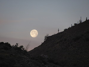
Old jeep road, new trail by DarthStiller  This trail is an old jeep road that has been redone a little bit to serve as one of the main entry trails into the new northern expansion of the McDowell Sonoran Preserve. It starts at the Fraesfield Trailhead and heads directly north, terminating at Powerline Road #2. It intersects with three other trails before its termination point, providing some loop options on the eastern side of this new area. This trail is an old jeep road that has been redone a little bit to serve as one of the main entry trails into the new northern expansion of the McDowell Sonoran Preserve. It starts at the Fraesfield Trailhead and heads directly north, terminating at Powerline Road #2. It intersects with three other trails before its termination point, providing some loop options on the eastern side of this new area.The trail starts very wide, obviously a road that's been there for several years. To your left (west) Fraesfield Mountain is visible, as is the Whiskey Bottle Trail carved into the northeastern side of it. Directly ahead to the north is the powerline, which isn't the greatest view. Just beyond the powerline. However, is Granite Mountain. At about the half-mile point, the official trail branches off from the road and becomes a single track. This spot is marked well and is just before an abandoned steel tank of some kind. The single track eventually turns back to jeep roads, alternating along its way between the two. Views of Four Peaks to the east are visible and the Mazatzals to the northeast.
At the termination point, you have the option to follow Powerline Road #2 to another area of the park east or west or continue north on the Granite Mountain Trail to the Granite Mountain Loop Trail. All options lead to other intersections of trails that can loop you back to the Fraesfield Trailhead. This trail and area, in general, seem to be equally used by hikers, bikers, trail runners, and equestrians.
Check out the Official Route and Triplogs. Leave No Trace and +Add a Triplog after your hike to support this local community. One-Way Notice This hike is listed as One-Way. When hiking several trails on a single "hike", log it with a generic name that describes the hike. Then link the trails traveled, check out the example. | |||||||||||||||||||||||||||||||||||||||||||||||||||||||||||||||||||||||||||||||||||||||||||||||||||||||||||||||||||||||||||||||||||||||||||||||||||||||||||||||||||||||||||||||||||


