Route Editor

| Guide | ♦ | 17 Triplogs | 1 Topic |
details | drive | no permit | forecast | 🔥 route |
stats |
photos | triplogs | topic | location |
| 150 | 17 | 1 |
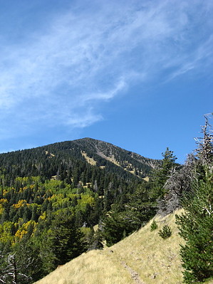
Autumn Masterpiece by Jim  Fremont Peak may be overlooked by most who hike the San Francisco Peaks, with many hikers wearing their Humphrey blinders. I can't blame them, but those hiker's loss is your gain, and Fremont Peak is an excellent summit with a lot of solitude. At 11,969', or just shy of 12,000', it is a solid alpine summit, and it shouldn't be overlooked or considered an easy hike because it is lower than Humphrey, as it is primarily off-trail. With the winter road closure and monsoon season, this hike is best in fall, from late September to late November or early December. If you are out here during the Rut, you'll hear and might see lots of Elk. The evidence is everywhere, as they love the grassy south faces of this mountain. Fremont Peak may be overlooked by most who hike the San Francisco Peaks, with many hikers wearing their Humphrey blinders. I can't blame them, but those hiker's loss is your gain, and Fremont Peak is an excellent summit with a lot of solitude. At 11,969', or just shy of 12,000', it is a solid alpine summit, and it shouldn't be overlooked or considered an easy hike because it is lower than Humphrey, as it is primarily off-trail. With the winter road closure and monsoon season, this hike is best in fall, from late September to late November or early December. If you are out here during the Rut, you'll hear and might see lots of Elk. The evidence is everywhere, as they love the grassy south faces of this mountain.The hike begins from Schultz Tank, where you will hike up the Weatherford Trail #102 for a couple of miles, passing the Kachina Trail #150 junction, and continuing up Weatherford Canyon. At the sign-in box, you can either go directly up the grassy slope which is above you on the right, or the east side and is a west-facing slope, or you can continue on the Weatherford Trail up several gently switchbacks to the same spot. When the aspen are at their peak, the trail is probably better.
Once in any one of the long ski slopes of grass, you need only hike up to reach the summit. Yes, it is steep, and you will have to work your way through a few more areas of trees, some of which are bristlecone pines and are very windblown. There are many thorny shrubs patched in spots near the treeline, and you will have to make your way through some of these. As you near the summit, some small boulder fields and scree slopes need crossing, with a thin and rugged ridge of rock being the last real obstacle you need to traverse. Once on the summit, take in the grandeur of Peaks, and use caution returning to your car. The slopes are steep, there are loose rocks in lots of places nicely hidden in the tall grass, and there are ungulate pellets everywhere that act like ball bearings underfoot! Of note, there is Senecio on Fremont, so take care not to step on that plant. Fremont is not off-limits at any time of year, but it is nice to protect what the Peaks have.
Check out the Official Route and Triplogs. Note This is a more difficult hike. It would be unwise to attempt this without prior experience hiking. Leave No Trace and +Add a Triplog after your hike to support this local community. | |||||||||||||||||||||||||||||||||||||||||||||||||||||||||||||||||||||||||||||||||||||||||||||||||||||||||||||||||||||||||||||||||||||||||||||||||||||||||||||||||||||||||||||||||||||||||||||||||||||||||||||||||||||||