🔥

Bridal Veil Falls - Mt Lemmon, AZ

Guide 7 Triplogs Mine 0 0 Topics
 
0 of 5 
Fav
Wish
0
details
drive
permit
forecast
🔥
route  
stats
photos
triplogs
topics
location
41 7 0
Statistics
tap icons for details
Difficulty 3.5 of 5
Route Finding 2 of 5
Distance Round Trip 11.7 miles
Trailhead Elevation 2,738 feet
Elevation Gain 2,690 feet
Accumulated Gain 3,200 feet
Avg Time Round Trip 6 hours
Kokopelli Seeds 27.7
 Interest Seasonal Waterfall & Seasonal Creek
 Backpack Yes - past 6 Miles
 Dogs not allowed
feature photo
Photos Viewed All MineFollowing
Will recalculate on button tap!
8  2020-04-09
Cathedral Rock - Hutch's Pool Traverse
LJW
2  2017-03-20 racer70m
5  2016-02-12 rvcarter
21  2015-10-31
Cardiac Gap
cms116508
13  2014-10-24 andrewbares
Author
author avatar Guides 1
Routes 1
Photos 84
Trips 1 map ( 6 miles )
Age 30 Male Gender
Location Tucson, AZ
Associated Areas
list map done
Tucson Region
Historical Weather
Trailhead Forecast
Radar Map
Expand Map
Preferred Mar, Nov, Feb, Jan
Seasons   Late Autumn to Early Spring
Sun  5:16am - 7:27pm
Official Route
 
1 Alternative
 
 Water
Historic Fire Perimetersacres
🔥 2020 Bighorn Fire119.5k
🔥 2003 Aspen Fire87.7 mi*
🔥 View (All) - over Official Route 🔥
*perimeter length in miles
Nearby Area Water
[ View More! ]
Fauna  Nearby
Flora  Nearby
Meteorology  Nearby
Named place  Nearby
Culture  Nearby
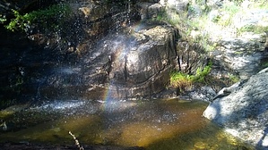
Desert waterfall in the lower Catalinas
by andrewbares

 
Overview
Bridal Veil Falls is a neat desert waterfall located up Esperero Canyon, on the way to Mt Lemmon. It doesn't seem to be visited often, but is worth seeing!Warning
The trail can be quite overgrown with desert grass. The grass has these "grass needles" that will work their way into trail running shoes (goes straight through the mesh) causing you to stop every 5 minutes to pull the needles out! Hiking shoes might be useful on this trail. The season probably also affects how much grass there is. I was there in October.

Hike
Most people will start from Sabino Canyon, which is the closest route to Bridal Falls. It's nearly 6 miles to Bridal Veil Falls, but the first 2 miles are quite flat. Then the majority of the elevation gain takes place between miles 2 and 4, with it leveling off again for the end.

The trail can be difficult to follow at times due to the overgrown grass. It seems like not many people hike this trail. However, with some decent trail-finding skills, you should do fine.

Remember that when crossing creeks/washes, you almost always cross perpendicular to the creek. Trails seldom travel up washes/creeks. Look for the cairn on the other side of the creek. The trail has cairns at wash/creek crossings, but that's about the only cairns you'll see.


Water Sources
As you near Bridal Veil Falls (like the last 1 mile), you'll be near running water. You'll of course need a filter. And I can't promise water will be running year-round.

Camping
There's a campsite right next to Bridal Veil Falls. Literally, right next to it. Way too close in my opinion (what happened to camping away from water sources?)

Resources


Check out the Official Route and Triplogs.

Leave No Trace and +Add a Triplog after your hike to support this local community.

2014-10-27 andrewbares
    WARNING! Hiking and outdoor related sports can be dangerous. Be responsible and prepare for the trip. Study the area you are entering and plan accordingly. Dress for the current and unexpected weather changes. Take plenty of water. Never go alone. Make an itinerary with your plan(s), route(s), destination(s) and expected return time. Give your itinerary to trusted family and/or friends.

     Permit $$
    AZ State Parks more info
    2021 Day Use Fees range from $2–$30

    Coronado Forest
    MVUMs are rarely necessary to review unless mentioned in the description or directions
    Coronado Motor Vehicle Use Maps (MVUMs)


     Directions
    or
    or
     Road
    Paved - Car Okay

    To Sabino Canyon Recreation Trailhead
    From the intersection of Tanque Verde and Grant/Kolb Rd head northeast on Tanque Verde. Turn left at the second light on Sabino Canyon Rd. Go about 8 miles up Sabino Canyon Rd and you come to a four way stop with Sunrise. Go straight through the intersection and take the next right into the parking lot of Sabino Canyon Recreation Area. Signs marking the way start on North Kolb road.

    This is the universal directions to Sabino Canyon Recreation Center. Hikes take off from all directions and some you might need to hike another trail to get to the start of your hike. Reference the hike summary for details.

    From PHX (I-10 & AZ-51) 117 mi - about 1 hour 57 mins
    From TUC (Jct 1-10 & Grant) 14.1 mi - about 30 mins
    From FLG (Jct I-17 & I-40) 261 mi - about 4 hours 1 min
    page created by andrewbares on Oct 25 2014 10:21 pm
     90+° 8am - 6pm kills
    helpcorrectionissue

    end of page marker