 Route Editor

| Guide | ♦ | 27 Triplogs | 1 Topic |
details | drive | permit | forecast | 🔥 route |
stats |
photos | triplogs | topic | location |
| 136 | 27 | 1 |
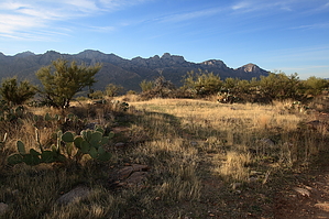
The name's funny enough by fricknaley  Background BackgroundThe 50 Year Trail is a mountain bike favorite out of Catalina State Park. Looking at the map, it seems that it would run along some nice, seldom visited desert and offer unique views of the Catalinas. Plus, it's long. Baby Jesus has the coolest name ever for a trail. This is an unusual hike for Tucson in that you can log 20+ miles without 4000-7000 feet. Usually, that kind of gain is exactly what I'm looking for, but now and then, you need something different, right? Hike From the ubiquitous Trailhead in Catalina State Park, take off from the back corner onto the Bridle Trail. This is nothing but a short connector segment to get you over to the 50 Year Trail's official beginning. It's a short, easy walk straight west. After o.6 miles, you will cross the road leading to the group camping area. Pick the trail up on the other side and continue 0.8 fast miles to the official 50 Year trailhead, 1.4 miles from the parking lot. There is a sign announcing your arrival, and the trailhead takes off from the back of the Equestrian Center. You are now going to hike north, then northeast for a long way. The trail starts wide and sandy but narrows down before too long to a comfortable trail wandering through the desert. There are always fantastic views of Pusch Ridge, then later of Samaniego Ridge and Charouleau Gap and it's neighboring Peak 5961 to the north to be had. After about 4 miles total, you will come to a small fence to pass through, marking the park boundary and entering State Trust Land. The trail makes a hard right just through the fence, then continues back on its normal course. Of note, the trail is generally always well-signed, and there are a lot of nameless trails braking off all over, but they should never really fool you.
You can head back the long way or look for a certain unnamed branch point atop a ridge. A trail sign right here sends you one way, and a clear wide trail goes the opposite. You can take this as a shortcut back to the main 50 Year trail and shave off about 1.2 miles on the way back. At (32.49520, -110.86765) make a left on your way back instead on the signed right down the slope to access this shortcut route. It's probably only a 0.3-mile route at most. Just make all the rights whenever there is a split, and you'll end up back on the 50 Year trail right at a sign marker. Head back to the FSR 642 for the next leg. At FSR 642, make a left onto the road, crossing over the cattle guard and passing through the open gate. Head down the rocky road, making rights whenever you see a split in the road. After about 0.5 miles on the rough road, you'll bottom out in a circular wash. On the other side of the wash is a rickety old fence with some ill-defined paths leading off. Interestingly, even though the Baby Jesus trail appears on two separate Catalinas maps, it is not signed on either end. The first trail far right is NOT the one you want. Look one or two to the left and see a small gate through the fence with a little brown sign simply stating no motorized vehicles and another small sign saying something to the effect of Rehabilitation Area or something like that. No mention of the trail name, but you'll know it's the Baby Jesus because it's the only one with any signage at all. My GPS told me I was 14 miles in here. The maps say the Baby Jesus is 3.8 miles. So away you go. The trail is rather primitive, and if you look at it, you will see testimony to how overgrown it is. This was not the case on this day. Primitive yes, but there's much worse in the Catalinas or Superstitions or wherever you call home. There is always something to follow and enough traffic to generate some prints to follow. It's a narrow trail the runs southeast then south behind Baby Jesus Ridge and its famed petroglyphs. There are several creek/wash crossing along the way, and there may well be some water trickling by. The hike's only real climbing is along this segment, but it's less than 1000 feet. The trail affords spectacular views into the high country of Samaniego and the Catalinas. As long as you closely scrutinize the route and path, you will not get lost. Roughly 2.75 miles or so from the beginning of the Baby Jesus, you will come to a large cement spring named Wooden Trough Spring. The trail cuts down in front of the trail here and to the right, descending slightly to cross some washes and ultimately heading towards some power lines that cut up Cargodera Canyon to Mt. Lemmon. The power lines signify the end of the sweet Baby Jesus trail at the Sutherland Trail. You'll know the Sutherland for it's a wide rocky road in this stretch. There is no sign marking the trail intersection. Only a moderate sized-cairn signifies the Baby Jesus trail on this end. Turn right onto the Sutherland and prepare for a mile of the worst torture as you stumble a mile sharply down the rocky road, which just brutalized your feet and ankles after a good 17.5+ plus miles on the trail. Do what you have to do to make it down this mile, where the Sutherland breaks off the road at a signed intersection, to the right back into the foothills. From here, it is a much more smooth 1.8-mile descent amidst magnificent views of the mountains down into Sutherland Wash, where a sign points you the right, last 0.8 merciful miles back to the trailhead. A couple of nice wash crossings in this final stretch often have water running, even when it appears dry at the Romero trailhead. Total mileage is about 21.4 for this trip, through some lovely country. Please don't try this hike when it's hot. There is almost no shade at all. Gate Policy: If a gate is closed upon arrival, leave it closed after you go through. If it is open, leave it open. Leaving a closed gate open may put cattle in danger. Closing an open gate may cut them off from water. Please be respectful, leave gates as found. The exception is signage on the gate directing you otherwise. Check out the Official Route and Triplogs. Note This is a moderately difficult hike. Leave No Trace and +Add a Triplog after your hike to support this local community. | |||||||||||||||||||||||||||||||||||||||||||||||||||||||||||||||||||||||||||||||||||||||||||||||||||||||||||||||||||||||||||||||||||||||||||||||||||||||||||||||||||||||||||||||||||||||||||||||||||||||||||||||||||||||||||||||||


