username
X
password
register
for free!
help
   🔥

Sutherland - Romero Loop, AZ

Guide 13 Triplogs  0 Topics
  4.2 of 5  
Fav
Wish
1
details
drive
permit
forecast
🔥
route  
stats
photos
triplogs
topics
location
68 13 0
Statistics
tap row or icons for details
Difficulty 4 of 5
Route Finding 4 of 5
Distance Loop 21.4 miles
Trailhead Elevation 2,719 feet
Elevation Gain 5,810 feet
Accumulated Gain 6,801 feet
Avg Time Round Trip 12
Kokopelli Seeds 55.41
 Interest Off-Trail Hiking, Historic & Seasonal Creek
 Backpack Yes
 Dogs not allowed
feature photo
Photos Viewed All MineFollowing
Will recalculate on button tap!
10  2022-03-17 LindaAnn
5  2022-03-17 Mountain_Rat
4  2019-10-26 ShatteredArm
10  2019-01-05 vivisectvi
8  2016-02-28 JuanJaimeiii
7  2016-02-28 joebartels
22  2015-03-07 Pivo
2  2015-02-11 Mountain_Rat
Page 1,  2
Author
author avatar Guides 11
Routes 123
Photos 818
Trips 257 map ( 2,596 miles )
Age 62 Male Gender
Location Tucson, AZ
Associated Areas
list map done
Tucson Region
Historical Weather
Trailhead Forecast
Radar Map
Expand Map
Preferred Oct, Apr, May, Nov → 6 AM
Sun  6:01am - 6:43pm
Official Route & 5 Rts
 
1 Alternative
 
Historic Fire Perimetersacres
🔥 2020 Bighorn Fire119.5k
🔥 2003 Aspen Fire87.7 mi*
🔥 View (All) - over Official Route 🔥
*perimeter length in miles


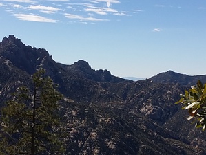
Western Lemmon Loop
by Mountain_Rat

Having completed this run from both directions, I find it worthy of its own description, so I present you the Sutherland-Romero Loop.


I won't bore you with mile-by-mile details. In summary, it's the Sutherland #6 and the Romero #8, linked together by the Mt. Lemmon #5. I first did this run late in 2012 in a counter-clockwise direction, as it seemed most feasible. I stand by that theory in that it divides the climb by more distance. The second time was to be the more challenging, clockwise direction which proves to be notably more of a challenge.
remove free decal offer
Highlights of the trip include views in all directions; the biosphere, Samaniego Peak, a nice mid-day view of sun through the window (look south from Sutherland Ridge from time to time), an ominous look down the Canada Del Oro, Pusch Ridge and much more. There's also a section of upper Sutherland that will test your route finding skills as no trail exists there anymore. This section can be easily navigated if done slowly and calmly. For the most part, you will always be in view of the next cairn or tree flagging.

Whichever direction you choose to go, this is a rewarding trip. Pack a lunch and enjoy ;)

2015-02-12 Mountain_Rat


    Check out the Official Route and Triplogs.

    Note
    This is a moderately difficult hike.
    Leave No Trace and +Add a Triplog after your hike to support this local community.
    WARNING! Hiking and outdoor related sports can be dangerous. Be responsible and prepare for the trip. Study the area you are entering and plan accordingly. Dress for the current and unexpected weather changes. Take plenty of water. Never go alone. Make an itinerary with your plan(s), route(s), destination(s) and expected return time. Give your itinerary to trusted family and/or friends.

     Permit $$
    AZ State Parks more info
    2023 Day Use Fees range from $2–$30


     Directions
    or
     Road
    Connector trail - Not Applicable

    To Catalina State Park Trailhead
    From Phoenix take 1-10 south to the 241 exit (Tangerine). Follow east to AZ 77 (Oracle Road). Turn right (South) on AZ77 and signs for Catalina State Park lead the way.

    From anywhere in Tucson, connect to Oracle Rd (Highway 77) and head north past Pusch Ridge. After you have gone about 15-20 miles you will see the sign for Catalina State Park on the right. There is an entrance fee to get into the park. To get to the trails, just drive in and follow the signs to a large parking area marked "trailhead".

    From PHX (I-10 & AZ-51) 107 mi - about 1 hour 44 mins
    From TUC (Jct 1-10 & Grant) 14.0 mi - about 23 mins
    From FLG (Jct I-17 & I-40) 251 mi - about 3 hours 50 mins
    page created by Mountain_Rat on Feb 12 2015 1:28 pm
     90+° 8am - 6pm kills
    helpcorrectionissue

    end of page marker