username
X
password
register
for free!
help
 

Cliff Walk Trail - Sonoran Preserve North, AZ

Guide 42 Triplogs  0 Topics
  2.6 of 5  
Fav
Wish
1
details
drive
no permit
forecast
route  
stats
photos
triplogs
topics
location
369 42 0
Statistics
tap row or icons for details
Difficulty 1 of 5
Route Finding 1 of 5
Distance One Way 2.88 miles
Trailhead Elevation 1,766 feet
Elevation Gain 190 feet
Accumulated Gain 554 feet
Avg Time One Way 4 hours
Kokopelli Seeds 4.73
 Backpack No
feature photo
Photos Viewed All MineFollowing
Will recalculate on button tap!
15  2024-12-18
Apache Wash Trail - Sonoran Preserve N
kingsnake
4  2024-10-24
Apache Wash Loop
Nightstalker
3  2024-07-29 mt98dew
6  2024-07-27 DarthStiller
2  2024-02-25
Apache Wash - Esplanade Loop
BiFrost
19  2021-05-02
Phoenix Sonoran Preserve N - East Side
tibber
8  2021-03-29
Sonoran Preserve Loop
trekkin_gecko
9  2021-03-29
Sonoran Preserve Loop
tibber
Page 1,  2,  3
Author
author avatar Guides 595
Routes 0
Photos 0
Trips 247 map ( 429 miles )
Age ?
Location
Associated Areas
list map done
Phoenix Region
Historical Weather
Trailhead Forecast
Radar Map
Expand Map
Preferred Feb, Nov, Jan, Mar → 7 AM
Seasons   Autumn to Spring
Sun  6:04am - 6:50pm
Official Route & 6 Rts
 
17 Alternative


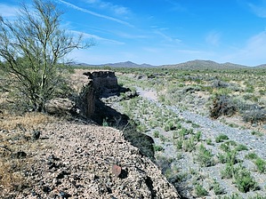
Not your Cliffs of Dover
by Unregistered

From the Apache Wash Trailhead you need to start on the Apache Wash Loop Trail. Hike for a half mile then connect to the Badger Brawl Trail for the next 1.55 miles where you will reach the Cliff Walk Trail. The Cliff Walk Trail is 2.88 miles one way.


Once you are on this trail it is easy to figure out where the name came from. The trail follows the Cave Creek river bed for its entire length. The trail has some great views of the area and is well marked all way.
remove free decal offer
I did not see any other hikers on the trail but did see about half a dozen bike riders. It seems like a great place to ride bikes too. Lots of birds and butterflies were witnessed on my February hike.

My hike started at Apache Wash Trailhead. I hiked to the end of the Cliff Walk Trail which ends at a bridge on the E. Carefree Hwy. From there I retraced my route back to the Apache Wash TH for a 10.15 mi out-n-back hike. There may be unofficial places to park near the north end of the trail along the E. Carefree Hwy. Which in theory would allow you to do a 6 mi out-n-back hike.

2015-02-22 Unregistered
  • Sonoran Preserve - North Map
    area related
    Sonoran Preserve - North Map
  • SPN - West Side Map
    area related
    SPN - West Side Map
  • SPN - East Side Map
    area related
    SPN - East Side Map


Check out the Official Route and Triplogs.
Leave No Trace and +Add a Triplog after your hike to support this local community.

One-Way Notice
This hike is listed as One-Way.

When hiking several trails on a single "hike", log it with a generic name that describes the hike. Then link the trails traveled, check out the example.
WARNING! Hiking and outdoor related sports can be dangerous. Be responsible and prepare for the trip. Study the area you are entering and plan accordingly. Dress for the current and unexpected weather changes. Take plenty of water. Never go alone. Make an itinerary with your plan(s), route(s), destination(s) and expected return time. Give your itinerary to trusted family and/or friends.

 Permit $$
None


 Directions
or
 Road
Paved - Car Okay

To hike
From Phoenix take the 101 east and exit on N Cave Creek Rd. Head north until you reach E.Sonoran Desert Dr. Turn left and drive about five miles and turn right on Apache Wash Trailhead. There are restrooms at the trailhead but no drinkable water.
page created by RowdyandMe on Feb 21 2015 8:53 pm
 90+° 8am - 6pm kills
helpcorrectionissue

end of page marker