 Route Editor

| Guide | ♦ | 26 Triplogs | 0 Topics |
details | drive | permit | forecast | 🔥 route |
stats |
photos | triplogs | topics | location |
| 95 | 26 | 0 |
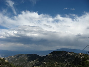
Scenic Segment by Jim  I was introduced to this trail when I hiked the similarly named description to Leopold Point. A new trail from the end of the Incinerator Road to the San Pedro Vista has surfaced. According to an internet resource, #18A was built in late 2012. I suspect it may have been a social trail before that. This trail is not signed with a USFS Metal sign at the San Pedro Vista but is signed at the end of the Incinerator Road as Trail #18A, Incinerator Ridge Trail. There is an AZT signpost at the start of the trail at the north end of the San Pedro Vista. I was introduced to this trail when I hiked the similarly named description to Leopold Point. A new trail from the end of the Incinerator Road to the San Pedro Vista has surfaced. According to an internet resource, #18A was built in late 2012. I suspect it may have been a social trail before that. This trail is not signed with a USFS Metal sign at the San Pedro Vista but is signed at the end of the Incinerator Road as Trail #18A, Incinerator Ridge Trail. There is an AZT signpost at the start of the trail at the north end of the San Pedro Vista.Overall, this is a short segment with outstanding views off of either side of this generally north-south trending ridge. The trail is short, but can easily be combined with other trails to produce an out and back to a logical high point of Mount Bigelow, or loops using other trails. Views range from the Pinaleno Mountains to the Tucson Mountains, The Superstitions to the Santa Ritas, and possibly as far away as the White Mountains.
Though this trail ends or begins at the sign, the Kellogg Mountain Trail #45 makes a logical continuation to head to Mount Bigelow. Because you are never really far from the Catalina Highway, you might hear traffic for most of the hike, especially on weekends. However, this does allow for easier starting and stopping points using other trails. Check out the Official Route and Triplogs. Leave No Trace and +Add a Triplog after your hike to support this local community. One-Way Notice This hike is listed as One-Way. When hiking several trails on a single "hike", log it with a generic name that describes the hike. Then link the trails traveled, check out the example. | |||||||||||||||||||||||||||||||||||||||||||||||||||||||||||||||||||||||||||||||||||||||||||||||||||||||||||||||||||||||||||||||||||||||||||||||||||||||||||||||||||||||||||||||||||||||||||||||||||||||||||||||||


