Route Editor

| Guide | ♦ | 4 Triplogs | 0 Topics |
details | drive | permit | forecast | 🔥 route |
stats |
photos | triplogs | topics | location |
| 17 | 4 | 0 |
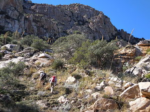
Some good, some bad by rvcarter  Warnings WarningsNo trail exists along much of this route - rough bushwhacking and high class 3 scrambling required! Also note that this entire area is contained within the Bighorn Sheep Management Area and is therefore off-limits (except for the 400-foot buffer on either side of the Pima Canyon Trail) between January 1 and April 30th, each year. Dogs are forbidden throughout the year. Background It was somewhat of a surprise that there were no hike descriptions currently for Bighorn Mountain, that prominent, middle peak between Pusch Peak and Table Mountain along Pusch Ridge. Nearly all of the HAZ routes in the area which reach Bighorn originate from Pima Canyon, with their destinations either the Cleaver or Table Mountain, both tough-to-reach because of the difficult terrain and few trails once you leave the Pima Canyon Trail. Bighorn rises to 5633 feet, a point higher than other peaks along Pusch Ridge southwest of Table Mountain (which is 6265 feet). Its summit provides excellent views of the Cleaver, Pusch Peak, Table Mountain Prominent Point, and other points in all directions. The Pima Canyon Trail is visible down below to the southeast.
This hike/climb begins at Rams Field Pass, a subdivision in Oro Valley just off Oracle Road south of Catalina State Park. Turn east into the subdivision and take the left onto E. Broken Rock Drive and go about 1100 feet to just past the dyke (nearly to the circular turnaround). It is ok to park along the road. Head south along the east side of the dyke and follow the obvious trail southeast into and through the unnamed, winding canyon. Avoid the temptation to turn onto any of the other trails that frequent the area. Continue past the Cottonwood Tank (a little over a mile into the hike, at 12S 506953, 3584450) to a semi-waterfall/pour-off fed by a seepy spring that is the source of water for the tank. The trail from the tank to the waterfall follows along a 2-inch pipe that appears to no longer be in use. The waterfall (about 1.75 miles from the TH, at 12S 507216, 3583666) is the terminus for most people hiking in this canyon. This is where the fun starts. It kind of fits in the category of misadventures that begin with “here, hold my beer and watch this”. You continue up the canyon following the wash where possible (if you stray outside the wash, you’re asking for trouble). There is lots of boulder hopping and class 3 scrambling, but nothing serious. The canyon is beautiful throughout, and the saddle and peak are visible at several points so one can plot the route up. It is a lot of fun, and there are few thorny plants in the wash. We were well up the canyon when my hiking partners outvoted me and choose Bighorn Mountain as the destination, instead of the, apparently easier, saddle between Bighorn and Table. So we climbed out of the wash southwest toward a ramp with several trees and bushes that appeared to offer an opening to the top. After some scouting and cliffing-out, we found a way around the cliff and after a sharp left turn (nearly south), headed more or less toward the top, picking a route between boulders, trees, and cliffs. Although the going was steep and tough, it was never more than a high class 3 scramble. However, there are lots of sharp, sticky things along the way; we all got beat up and stuck up pretty good. Finally, at the ridge, we discovered we were only a couple hundred feet northeast of Bighorn and moved there for lunch. Since we had left a vehicle at the Pima Canyon TH at the end of E. Mcgee Road, we continued out that way. We planned to find the steep gash off Pima Canyon Trail above the second dam and go down that. Most people going to Table Mountain go up and down that way, and it’s the shortest way back to Pima Canyon Trail. Unfortunately, we dropped down from Bighorn too soon and missed the top of the gash by over ¼ mile (and several hundred feet of elevation), so we decided to go southwest down the ridge along a route Frank and I had taken on a previous trip up to Table. Beware that the whole south side of Pusch Ridge is awash in shin daggers. Wear your gaiters (or chaps, if you have them). More Information For more details about the plateau-ish area leading up to Table Mountain (which is the same plateau leading down from Bighorn), as well as the route up the canyon from the Pima Canyon Trail, look at brianb’s excellent description “Table Mountain – Catalinas, AZ” (aptly named “Torture”). Check out the Official Route and Triplogs. Leave No Trace and +Add a Triplog after your hike & climb trip to support this local community. | |||||||||||||||||||||||||||||||||||||||||||||||||||||||||||||||||||||||||||||||||||||||||||||||||||||||||||||||||||||||||||||