Overview
Shares Turnbuckle origin at the lower end. Follows ravines adjacent-east of Turnbuckle then ends back at upper-east Turnbuckle. Emergency trail post markers are a simple MW.
Hike
From the main parking lot, crossing the bridge puts you on MW mid-trail.
Left/West is 0.2 mi to the origin. Two core trails with an origin off-kilter from parking are the only oddity in this nearly perfectly planned park.
Right/East skirts 0.2 mi before curving northwest up a large... mountain wash! The most intriguing portion works up a tributary. Lost Creek Trail splits off to the east. MW ends hooking back south to meet the upper Turnbuckle Trail.
Options with various park trails are plentiful. This trail does escape between wedged ridges quickly. The eastern ridge notably draws attention and intrigue. Lucky you, Skyline Crest Trail dances that beat via Lost Creek Trail.
Synopsis
A functional link, a gateway to options. Far from blah, just not topping any favorite lists.
Gate Policy: If a gate is closed upon arrival, leave it closed after you go through. If it is open, leave it open. Leaving a closed gate open may put cattle in danger. Closing an open gate may cut them off from water. Please be respectful, leave gates as found. The exception is signage on the gate directing you otherwise.
When hiking several trails on a single "hike", log it with a generic name that describes the hike. Then link the trails traveled, check out the example.
WARNING! Hiking and outdoor related sports can be dangerous. Be responsible and prepare for the trip. Study the area you are entering and plan accordingly. Dress for the current and unexpected weather changes. Take plenty of water. Never go alone. Make an itinerary with your plan(s), route(s), destination(s) and expected return time. Give your itinerary to trusted family and/or friends.
Permit $$
no fees or permits reported
if incorrect tell us about it
Directions
Road
Connector trail - Not Applicable
To Skyline Park Trailhead From Phoenix, take I-10 west to Watson Rd. Exit, and go north on Watson. Take Watson north approx 2 miles into the park.
The Entrance Lot is immediately after the gate where Watson turns 90 degrees west(left)
About 10-12 cars slot park on dirt just off the edge of the road.
- Parking Lot Connector Trail
- mid access to Quartz Trail
The developed Discovery Point Lot is 0.3 miles further in on Watson.
I'm not 100% sure on that name, needs verified. It's an obvious half moon oval.
- mid access to Parking Lot Connector Trail
The Main Lot is another 0.3 miles at the end of the road.
- all else, the majority
Park entry is FREE! Trails open sunrise to sunset. Gates close at 10 p.m.
From PHX (I-10 & AZ-51) 36 min (34.9 miles) From TUC (Jct 1-10 & Grant) 2 h 3 min (142 miles) From FLG (Jct I-17 & I-40) 2 h 22 min (159 miles)
 Route Editor

 Overview
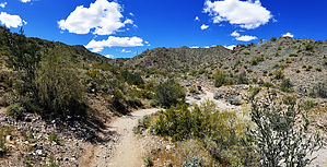


