Overview
The western mile of Lost Creek Trail is managed by Skyline Regional Park. It connects Mountain Wash Trail, Skyline Crest Trail, Quartz Mine Trail, and continues 0.3 miles to the park boundary. It continues another mile east on BLM property to the Verrado Community.
Hike
This is an old road christened to trail status. It is essentially used to bridge loop hikes in Skyline Park and connect the Verrado trail system. Tread is of little concern throughout. There are occasional ankle buster rocks up to maybe grapefruit-sized, but the road, I mean the trail, is so wide you navigate 'em without thought.
The western Skyline side has quicker changing views and excellent signage at all official trail junctions.
Synopsis
Lost Creek Trail is not a destination, and it's nothing to get excited over. It does an excellent job of connecting opportunities and has intriguing characteristics.
When hiking several trails on a single "hike", log it with a generic name that describes the hike. Then link the trails traveled, check out the example.
WARNING! Hiking and outdoor related sports can be dangerous. Be responsible and prepare for the trip. Study the area you are entering and plan accordingly. Dress for the current and unexpected weather changes. Take plenty of water. Never go alone. Make an itinerary with your plan(s), route(s), destination(s) and expected return time. Give your itinerary to trusted family and/or friends.
Permit $$
no fees or permits reported
if incorrect tell us about it
Directions
Road
Connector trail - Not Applicable
To Skyline Park Trailhead From Phoenix, take I-10 west to Watson Rd. Exit, and go north on Watson. Take Watson north approx 2 miles into the park.
The Entrance Lot is immediately after the gate where Watson turns 90 degrees west(left)
About 10-12 cars slot park on dirt just off the edge of the road.
- Parking Lot Connector Trail
- mid access to Quartz Trail
The developed Discovery Point Lot is 0.3 miles further in on Watson.
I'm not 100% sure on that name, needs verified. It's an obvious half moon oval.
- mid access to Parking Lot Connector Trail
The Main Lot is another 0.3 miles at the end of the road.
- all else, the majority
Park entry is FREE! Trails open sunrise to sunset. Gates close at 10 p.m.
From PHX (I-10 & AZ-51) 36 min (34.9 miles) From TUC (Jct 1-10 & Grant) 2 h 3 min (142 miles) From FLG (Jct I-17 & I-40) 2 h 22 min (159 miles)
 Route Editor

 Overview
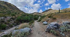


