Route Editor

| Guide | ♦ | 15 Triplogs | 1 Topic |
details | drive | permit | forecast | route |
stats |
photos | triplogs | topic | location |
| 134 | 15 | 1 |
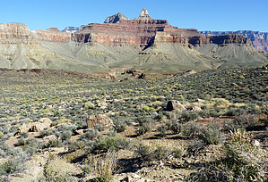
The Pony Loop by ckoss_   Preface PrefaceThe Transcanyon Waterline project has impacted the ability for popular Rim to Rim and Rim to River hiking itineraries. Currently, the River Trail and Silver Bridge are closed until Oct. 1, 2025 which spans the stretch of trail between River Resthouse by Pipe Creek and the South Kaibab Trail junction. Press Release Here. Hikers must use the Black Bridge to cross the Colorado River to visit Phantom Ranch. An alternative day hike or overnight hike is the Pony Loop. Check the NPS website for the most up-to-date closures. Overview This point-to-point trail network connects the popular Bright Angel Trail and the South Kaibab while remaining above the Tonto platform via the Tonto Trail. This section of the Tonto Trail is the most traveled since it connects the 2 South Rim corridor trails. This is a great opportunity to explore the Tonto platform if you have yet to step foot away from the corridor trails.
This can be extended to be a loop by combining it with the Rim Trail connecting the Bright Angel Trailhead and the South Kaibab Trailhead (5 miles), referred to as the Pony Loop. The name of this loop is due to the shorter version of the "Cowboy Loop", which would involve the full length of Bright Angel and South Kaibab Trails, with the River Trail. The Bright Angel Trail begins from the rim near Kolb Studios and descends into the head of a side canyon with 2 tunnels in the upper portion. There are water faucets and composting toilets at two resthouses: Mile-and-a-Half Resthouse and Three-Mile Resthouse. Check to make sure the water is turned on before descending the canyon. It is a total of 4.6 miles down Bright Angel Trail to arrive at the junction of Tonto Trail just below the camping and day use area of Havasupai Gardens. There is a wooden sign that says "Tonto East". Once on Tonto, it is 4.6 miles to the junction of Tonto and South Kaibab Trails. Look for the remains of various telephone wire posts throughout this section. This section of the Tonto Trail has 2 water sources: Burro Spring and Pipe Spring (water must be treated before drinking). During summer months, it is advisable to soak clothing to keep cool. The Tonto trail has no shade except for the areas surrounding Burro and Pipe springs. There is a shaded resthouse and composting toilets at the Tipoff, which is the junction of the Tonto and South Kaibab trails. This trail differs significantly from the Bright Angel Trail because it follows a ridgeline for nearly 4 miles before winding up the steep set of switchbacks referred to as the "Chimney". Water Sources There are water stations along Bright Angel Trail and at Havasupai Gardens. Check here to make sure the water is turned on before descending the canyon. This section of the Tonto Trail has 2 water sources: Burro Spring and Pipe Spring (water must be treated before drinking). Recall that there is no water on the South Kaibab, so plan accordingly, especially in the hot summer months. Camping Camping is only permitted with a Grand Canyon Backcountry permit at Havasupai Gardens, where the Tonto Trail intersects the Bright Angel Trail. Note This hike can be done in either direction. It is recommended that people who find difficulties with taking large steps down to go down Bright Angel and up South Kaibab. Check out the Official Route and Triplogs. Leave No Trace and +Add a Triplog after your hike to support this local community. | |||||||||||||||||||||||||||||||||||||||||||||||||||||||||||||||||||||||||||||||||||||||||||||||||||||||||||||||||||||||||||||||||||||||||||||||||||||||||||||||||||||||||||||||||||||