Route Editor

| Guide | ♦ | 8 Triplogs | 1 Topic |
details | drive | permit | forecast | route |
stats |
photos | triplogs | topic | location |
| 70 | 8 | 1 |
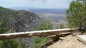
Slice of History by chumley   Evidence of old mining digs and foundations for an ore mill provides points of interest along a three-quarter-mile interpretive trail that begins and ends at the Reef Townsite Campground's northeastern end. Evidence of old mining digs and foundations for an ore mill provides points of interest along a three-quarter-mile interpretive trail that begins and ends at the Reef Townsite Campground's northeastern end.The campground is located on a site that was once occupied by the old mining town of Reef. That remote outpost got its name from the nearby Carr Reef, a tall band of quartzite-bearing cliffs that form the Huachuca Mountains' dramatic eastern front. Mining activity along the Reef began during the last few years of the nineteenth century and proceeded in fits and starts into the 1950s.
Many relics of Reef’s mining history, including the remains of the town’s old water system and various features, are still visible in and around the campground and the adjacent interpretive trail. Check out the Official Route and Triplogs. Leave No Trace and +Add a Triplog after your hike to support this local community. | ||||||||||||||||||||||||||||||||||||||||||||||||||||||||||||||||||||||||||||||||||