Route Editor

| Guide | ♦ | 1 Triplog | 0 Topics |
details | drive | permit | forecast | route |
stats |
photos | triplog | topics | location |
| 26 | 1 | 0 |
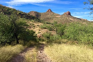
Trust me, no ropes/gear are needed… by AZHiker456  Like the nearby Rock Wall Peak, Diablo Mountain, and Sardina Peak, Puerto Peak can also easily be summited in a few hours or less, making it a great little ‘leg-stretcher’ type of adventure that will also provide fun, serenity, and sensational views. Located on a well-maintained dirt road less than 7 miles from I-19, it is very accessible and requires just a 15-20 minute drive to reach the take-off point. If you’re looking for a longer adventure, simply combine it with one or more of the aforementioned peaks and/or one or more of the myriad of other fun-looking, unnamed peaks that the area has to offer. Like the nearby Rock Wall Peak, Diablo Mountain, and Sardina Peak, Puerto Peak can also easily be summited in a few hours or less, making it a great little ‘leg-stretcher’ type of adventure that will also provide fun, serenity, and sensational views. Located on a well-maintained dirt road less than 7 miles from I-19, it is very accessible and requires just a 15-20 minute drive to reach the take-off point. If you’re looking for a longer adventure, simply combine it with one or more of the aforementioned peaks and/or one or more of the myriad of other fun-looking, unnamed peaks that the area has to offer.Hike [Note: there are often many options for off-trail hiking/peak bagging; described below is the route I took to this peak]: For just under 1.5 miles, you’ll be hiking along an unnamed jeep road [see the directions section for specifics]. The jeep road gradually gains elevation as it winds up and around a Western tributary of Puerto Canyon, flanking the canyon on the south side. Then, at a saddle-like area, [BM 4110 on Cal / FS Topo maps], the road, [which had been heading Westward], shifts and heads Northward. From this point, you’ll continue along the jeep road for 0.60 more miles, at which point the real fun begins as you start the off-trail segment.
…and will probably have you thinking, ‘no way is Puerto doable without ropes/gear!’ Fear not; as the subtitle says: “trust me, no ropes/gears are needed…”; but you’ll need to be comfortable with some rock scrambling / Class 2 climbs. Despite the near-vertical appearance of Puerto, just keep heading toward it. The short ridgeline from the unnamed peak to Puerto is routed; and the routes lead right to the base of Puerto, positioning you to negotiate the final short section that demands some fun, basic bouldering skills to reach the top. And best of all for those who are intimidated by exposure: despite how daunting it may appear from a distance, the exposure is very minimal. Like most of the nearby peaks, the views from Puerto will not disappoint and can be summed up as: 360 degrees of awesome in all directions! With many unique shaped peaks to marvel at in the immediate vicinity, as well as other beautiful ranges in the distance like the Santa Ritas to add to the backdrop, the views from atop Puerto Peak are sensational, to say the least. There is a rock pile by the highpoint, but no summit register than I could find. After enjoying the amazing views, take the short scramble back down to the base of Puerto and then start to contour around it, heading clockwise. There is another cliff-like peak located immediately to the East and slightly to the North of Puerto, so if you’ve opted to do this adventure without using GPS tracks or don’t feel like looking at them every step of the way, then simply head toward this unnamed peak as you begin your descent toward the SE. As long as you make sure to head downward to the South, then, [in a little over 0.75 miles], you will come out on FR 684; if, however, you head downward to the North [off the saddle area between Puerto Peak and the UN peak to the East of Puerto], then you’ll be in for a much longer adventure. The descent is a very pleasant one, particularly if you opt to visit the peak at a time of year when the brush is on the high side. Hiking poles may come in handy since there is some loose footing; however, nothing was very difficult, and the relative lack of brush and gradual grade makes for good visibility/maneuverability and a fairly fast descent. Once you come out on FR 684, you’ll then have a 0.40-mile stroll back to your vehicle. Check out the Official Route and Triplog. Leave No Trace and +Add a Triplog after your hike to support this local community. | |||||||||||||||||||||||||||||||||||||||||||||||||||||||||||||||||||||||||||||||||||||||||