Route Editor

| Guide | ♦ | 21 Triplogs | 2 Topics |
details | drive | no permit | forecast | 🔥 route |
stats |
photos | triplogs | topics | location |
| 293 | 21 | 2 |
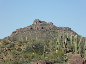
Why's this called "Old Turk's Head"? by Steph_and_Blake  2026 March Changes 2026 March ChangesThe Carney Spring Trailhead is closed. This hike now begins at the Lost Goldmine TH. It is 0.5 mile longer one-way and 16 feet less AEG. Overview After having hiked to Turk's Head several weeks ago, the gang decided to hike to the top of Old Turk's Head from the Carney Springs trailhead (heading west). The hiking was nice, easy, and after the first 0.5 miles or so, where we took a left onto the Lost Goldmine Trail #60, the wildflowers were beautiful. (It was rather windy, though, so please forgive my somewhat blurry photos.) Hike The trail meanders in and out of small drainages for about 1.5 miles just south of the Superstition Wilderness boundary. Along the way, you can see Turk's Head and, occasionally, Old Turk's Head in the background. We found the views of the Superstition Ridgeline interesting from this new perspective. We rounded the southern flank of Turk's Head and then abandoned the trail. However, we couldn't help but notice that someone(s) had put in a fair amount of effort to clear a path of vegetation up to some strange rock formations we passed about a third of the way to the top. Perhaps the weird rock formations are a popular place to hang out? We continued upward in a north-westerly direction, picking our way among the teddy bear chollas. Between the strange rock formations and the chute we went up, there was a fair amount of loose rock, so please be advised. Once on top, we had views of Picketpost, Dinosaur, Camelback, Red Mountain, and the Superstition Ridgeline. There was a nice, open space for lunch and (my mandatory) group photo. We decided to seek out a different path down to avoid the loose rock and found that by going straight east on a north-facing slope, we had better footing with plenty of stable grass. We made it down into a mostly dry drainage and utilized the bare rock until there was too much catclaw. From there, we left the drainage and headed south to pick up the Lost Goldmine Trail for a return to the Carney Springs trailhead. Check out the Official Route and Triplogs. Leave No Trace and +Add a Triplog after your hike to support this local community. | |||||||||||||||||||||||||||||||||||||||||||||||||||||||||||||||||||||||||||||||||||||||||||||||||||||||||||||||||||||||||||||||||||||||||||||||||||||||||||||||||||||||||||||||||||||||||||||||||||||||||