 Route Editor

| Guide | ♦ | 1 Triplog | 0 Topics |
details | drive | permit | forecast | route |
stats |
photos | triplog | topics | location |
| 40 | 1 | 0 |
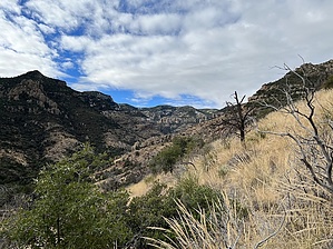
Faint trail with lots of promise by jacobemerick  Warning WarningThis trail is faint at best, with several sections that require solid route-finding skills or a willingness to barrel through prickly brush. Hikers should be prepared for an arduous, perhaps even multi-day, adventure to complete this trail. Overview Paddy's River Trail can be used with East Divide Trail to make a challenging Kennedy Peak loop, an alternative approach to Powers Garden via Rattlesnake Trail, or even an out-and-back to Paddy's River itself. It offers great views of the Pinalenos and the Galiuro river valleys for those willing to navigate its obstacles.
There have been several re-routes since the initial tread was laid, including a bypass at the beginning to avoid private property. The official route attempts to follow the re-routes. Hike There is a small pull-out next to the gate for Deer Creek Ranch, enough for one or two vehicles, though it is preferable to park at the Deer Creek Trailhead and walk the half-mile along FR 253. At the pull-out is a metal ladder over the barbed-wire fence with a few signs - notably, there is no indication that this is a trailhead or the start to Paddy's River Trail. Once on the other side, a narrow singletrack leads south through the grass towards some trees, which surround Home Ranch Tank. The trail circles around to the west, goes through a fence, and then meets up with an old two-track at 0.7 miles. Easy two-track walking doesn't last long. At 1.25 miles the track cuts east and an overgrown singletrack continues south, climbing uphill through a crowded mess of manzanita. If this is too thick for you, now is a good time to turn around, check out the views of Santa Teresa to the north, and retreat. Manzanita retreats at 1.5 miles and there is a brief respite across a grassy slope before entering an overgrown scrub forest. This was thick as of 2022 and required some crawling and detours to continue uphill. The saddle at 2.3 miles is hard-won and has excellent views south of Sulphur Spring Valley. Dropping down the saddle to the south is a different challenge. There are few sections of thick overgrowth, as most of the slope is sun-baked grass and rocks, although the intermittent cairns and faint path are difficult to track. The route follows the slope, sweeping in and out of the drainages, staying mostly level until 3.9 miles, where it drops down the last drainage before sidling over to Paddy's River. If the heat is too much or the trail too difficult to track then following any drainage down to the river may make a more enjoyable walk. The river is a slice of heaven. Similar to much of this range, the tall pines cluster around the creeks, making a pleasant valley with seasonal water flow and ample needle-cushioned camping opportunities. The tread is obvious along the river, staying to the north bank and usually within a few dozen yards of the riverbed. Too soon the climb starts (5 miles). Cross the northern tributaries coming down from Kennedy Peak and start up the slope. If you lose the tread at the beginning, it's worth the extra time to find it, as the switchbacks up the main climb are very useful. Numerous game paths compete with the tread, so be sure to watch for the short cairns, which mark each switchback. Much of this climb is fully exposed to the morning sun and offers an interesting perspective of the East Divide. At 5.7 miles the forest picks back up, which is even more overgrown and cluttered than the scrub a few miles back near Limestone Spring. Plenty of deadfall, boulders, and twisty growth has overtaken the trail. There are few options here - be prepared for lots of crawling and try not to mistake the cholla for helpful sticks. When the steepness begins to taper there are a few views to be had, partly obscured by surrounding trees. Continue west until you blunder out onto the relative highway of the East Divide Trail. There is a small campsite here so you can pull the sticks and leaves from your hair before continuing on your adventure. Water Sources Limestone Spring is along the first half of the trail and has a springbox. The spring itself has collapsed. Paddy's River may also have flow, depending on recent weather events. Camping Some good, but undeveloped, camping opportunities along Paddy's River. There is a fire ring and clearing at the upper end of the trail along East Divide. Gate Policy: If a gate is closed upon arrival, leave it closed after you go through. If it is open, leave it open. Leaving a closed gate open may put cattle in danger. Closing an open gate may cut them off from water. Please be respectful, leave gates as found. The exception is signage on the gate directing you otherwise. Check out the Official Route and Triplog. Note This is a difficult hike. Arrive fit and prepared or this could get ugly. Leave No Trace and +Add a Triplog after your hike to support this local community. One-Way Notice This hike is listed as One-Way. When hiking several trails on a single "hike", log it with a generic name that describes the hike. Then link the trails traveled, check out the example. | |||||||||||||||||||||||||||||||||||||||||||||||||||||||||||||||||||||||||||||||||||||||||


