The fabulous views keep coming along all 22 miles of this ridgetop trail. It snakes its way among the highest peaks in the Galiuros and sidesteps several of its significant canyons' upper reaches.
From the trailhead in Deer Creek, the East Divide Trail wanders its way along shallow drainages and grassy flats to the upper reaches of Oak Creek. It then follows this drainage to the top of the easternmost of the two ridges, which divide the Galiuros. Once atop the East Divide, the trail follows a ridgeline route past Kennedy, Sunset, and Bassett Peaks, offering good views of other prominent points in the mountain range, including Kielberg, Grassy, and Rhodes Peaks, as well as Biscuit, Maverick, and Cake Mountains. A quarter-mile side trip takes you to an even more impressive panorama atop Kennedy Peak, where the views stretch toward all compass points.
From the high ridge of the Galiuros' East Divide, the trail drops into the upper reaches of Douglas Canyon, where stands of Douglas-fir, ponderosa pine, and aspen provide the scenery. Paddys River, Sunset Canyon, and Redfield Canyon add more drama to the topography. Both to the east and the west, as the trail passes its junction with the High Creek Trail #290 and continues to the point where Bassett Peak Trail #287B tackles Bassett Peak's 7,663-foot summit, highest in the Galiuros. Here, the East Divide Trail drops off the high ridge and switchbacks down into Ash Creek Canyon, completing the last leg of its long and notable journey.
The East Divide Trail is also accessible via several other Galiuro Wilderness trails, including Tortilla #254, Corral Canyon #291, Paddys River #293, and High Creek #290 trails.
Notes
Portions of this trail can be challenging to follow. A topographic map and compass should be an essential part of your equipment when visiting here.
When hiking several trails on a single "hike", log it with a generic name that describes the hike. Then link the trails traveled, check out the example.
WARNING! Hiking and outdoor related sports can be dangerous. Be responsible and prepare for the trip. Study the area you are entering and plan accordingly. Dress for the current and unexpected weather changes. Take plenty of water. Never go alone. Make an itinerary with your plan(s), route(s), destination(s) and expected return time. Give your itinerary to trusted family and/or friends.
Permit $$
None
Coronado Forest MVUMs are rarely necessary to review unless mentioned in the description or directions Coronado Motor Vehicle Use Maps (MVUMs)
Directions
Road
High Clearance possible when dry
To Deer Creek Trailhead From I-70 & Klondyke Rd ( between Bylas / Safford )
35.9 mi, About 1 hr 6 mins
1. Head west on Klondyke Rd toward Siesta Del Retiro 24.6 mi
2. Turn left onto Bonita Klondyke Rd 4.6 mi
3. Turn right onto Deer Creek Rd 6.7 mi
From Wilcox AZ - Fort Grant Rd and I-10
54.4 mi, About 1 hr 21 mins
AZ-266 73.0 mi. About 1 hour 31 mins
1. Head northwest on Fort Grant Rd toward Virginia Ave 14.9 mi
2. Continue onto S Brookerson Rd 3.0 mi
3. Turn left onto Ash Creek 2.9 mi
4. Turn right onto Fort Grant Rd 8.6 mi
5. Turn left onto Bonita Aravaipa Rd 2.4 mi
6. Continue onto Bonita Klondyke Rd 15.9 mi
7. Turn left onto Deer Creek Rd 6.7 mi
From PHX (I-10 & AZ-51) - 3 hr 36 min (185 miles) From TUC (Jct 1-10 & Grant) - 2 hr 36 min (139 miles) From FLG (Jct I-17 & I-40) - 5 hr 30 min (273 miles)
 Route Editor

 The fabulous views keep coming along all 22 miles of this ridgetop trail. It snakes its way among the highest peaks in the Galiuros and sidesteps several of its significant canyons' upper reaches.
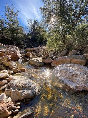


