username
X
password
register
for free!
help
   🔥

Carrie Nation Trail #78, AZ

Guide 29 Triplogs  0 Topics
  3.9 of 5  
Fav
Wish
0
details
drive
permit
forecast
🔥
route  
stats
photos
triplogs
topics
location
208 29 0
Statistics
tap row or icons for details
Difficulty 2.5 of 5
Distance One Way 1.5 miles
Trailhead Elevation 5,874 feet
Elevation Gain 1,327 feet
Avg Time One Way 1 hour
Kokopelli Seeds 5.92
 Interest Historic & Seasonal Creek
 Backpack Possible - Not Popular
feature photo
Photos Viewed All MineFollowing
Will recalculate on button tap!
12  2024-07-20
Jack Mountain Loop
chumley
14  2024-03-09
Bearpaw Rock & Pete Mountain Loop
rubywrangler
14  2023-11-12
Mount Hopkins from Madera Canyon
DixieFlyer
14  2023-10-28
Agua Caliente Trail #140
Jim
1  2023-07-09
Jack Mountain Loop
fricknaley
1  2022-07-25
Jack Mountain Loop
fricknaley
19  2021-07-26
Madera Canyon Scenes
rwstorm
7  2020-08-15
Crest Trail #144 - Santa Rita Mtns
PrestonSands
Page 1,  2
Author
author avatar Guides 187
Routes 989
Photos 12,068
Trips 864 map ( 6,882 miles )
Age 72 Male Gender
Location Tucson, Arizona
Associated Areas
list map done
Tucson Region
Historical Weather
Trailhead Forecast
Radar Map
Expand Map
Preferred Apr, Oct, Mar, Nov
Seasons   ALL
Sun  6:01am - 6:43pm
Official Route & 1 Rt
 
13 Alternative
 
Historic Fire Perimeteracres
🔥 2005 Florida Fire23.2k


vague in places
by markthurman53

The Carrie Nation Trail is not currently listed as a Trail, but I found Write-ups that refer to it as Trail #78. The Trail is a short 1.5 miles long, starting at the Vault Mine Trail and ending at the Agua Caliente Trail. The Trail is steep as you approach Agua Caliente Trail and in places hard to locate. The Carrie Nation Trail can be used as one leg of a loop hike or a means of getting to Jack Mountain.


The point of interest is the Carrie Nation Mine. This Mine was operating around 1903 and mined mainly Copper with some Lead, Zinc, and Molybdenum. The boiler used at the mine to provide steam power is still there and in fairly good condition despite someone using it for target practice (I guess if you’re not very good and there isn’t a broadside of a barn around this will do). The mine when I was there had water in it. If you like to visit old mines and old mining equipment then this is a good hike.
remove free decal offer
To get to this trail, take the Old Baldy trail for 0.3 miles, and stay straight as the Old Baldy Trail exits left. You are now on the Vault Mine Trail. Stay on the Vault Mine Trail for about 0.5 miles where the Vault mine Trail will exit right and the Carrie Nation Trail continue straight. There was no sign mentioning the Carrie Nation Trail. Follow the trail along the stream for about 0.3 miles, the trail will exit the stream to the west and do one switchback and follow above the stream along the West Bank. Continue for about 0.5 miles where the trail will cross the stream again and the Carrie nation Mine will be along the West bank.

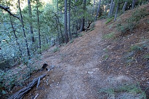
From here the trail gets a little vague in places. If you watch closely you will find the trail as it crosses on either side of the stream. Follow the stream up for about 0.3 miles to an elevation of about 6800 feet and the trail (visible here) will do one switchback up along the west side of the creek to the ridge (Once on the ridge you will notice a route that heads straight down the ridge. This is the route some take instead of the creek and will lead down to the Carrie Nation mine). On the ridge, you will see a well-beaten route that has been used by others to get to the Agua Caliente Trail. It is steep and a good workout. From the Agua Caliente trail, you will have to decide where you want to go, Left will take you to Josephine saddle, and right to Agua Caliente Saddle. I will go left to Jack Mountain and have some good views North and South.

2017-03-31 markthurman53


    Check out the Official Route and Triplogs.
    Leave No Trace and +Add a Triplog after your hike to support this local community.

    One-Way Notice
    This hike is listed as One-Way.

    When hiking several trails on a single "hike", log it with a generic name that describes the hike. Then link the trails traveled, check out the example.
    WARNING! Hiking and outdoor related sports can be dangerous. Be responsible and prepare for the trip. Study the area you are entering and plan accordingly. Dress for the current and unexpected weather changes. Take plenty of water. Never go alone. Make an itinerary with your plan(s), route(s), destination(s) and expected return time. Give your itinerary to trusted family and/or friends.

     Permit $$
    Visit overview & permits.
    2024 - FAQ
    $8 per vehicle per day
    $10 per vehicle per week
    $40 per vehicle per year (valid for one year from the date of purchase)

    There are four specific day-use areas that require a Coronado Recreational Pass or a National Pass/America the Beautiful Pass.
    1) Sabino Canyon - located on the Santa Catalina Ranger District (520)749-8700
    2) Madera Canyon - located on the Nogales Ranger District (520)281-2296
    3) Cave Creek - located on the Douglas Ranger District (520)364-3468
    4) Mt. Lemmon at 11 day-use sites.

    2022 Catalina State Park
    Per vehicle (1-4 Adults): $7.00
    Individual/bicycle: $3.00

    2022 Sabino Canyon Tram is $15 extra. [ website ]

    Coronado Forest
    MVUMs are rarely necessary to review unless mentioned in the description or directions
    Coronado Motor Vehicle Use Maps (MVUMs)


     Directions
    or
     Road
    Paved - Car Okay

    To Madera Canyon Trailhead
    From Tucson: I-19 south to exit 63 Continental. At the end of the exit take a left and follow brown signs to Madera Canyon. You'll be taking White House Canyon Road 13.2 miles to Madera Canyon.

    From PHX (I-10 & AZ-51) 152 mi - about 2 hours 31 mins
    From TUC (Jct 1-10 & Grant) 42.3 mi - about 55 mins
    From FLG (Jct I-17 & I-40) 295 mi - about 4 hours 37 mins
    page created by markthurman53 on Mar 31 2017 5:36 pm
     90+° 8am - 6pm kills
    helpcorrectionissue

    end of page marker