 Route Editor

| Guide | ♦ | 4 Triplogs | 0 Topics |
details | drive | no permit | forecast | 🔥 route |
stats |
photos | triplogs | topics | location |
| 17 | 4 | 0 |
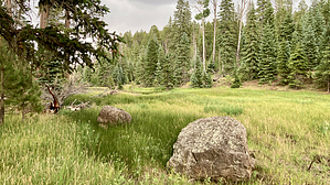
To ski or not to ski by chumley  This is officially a winter ski route, but its proximity to Hannagan Meadow means it gets some regular maintenance. And it's a nice easy stroll for anybody staying at the nearby lodge or campground. This is officially a winter ski route, but its proximity to Hannagan Meadow means it gets some regular maintenance. And it's a nice easy stroll for anybody staying at the nearby lodge or campground.Starting at the trailhead for the Foote Creek and Steeple trails across the highway from the Hannagan Meadow campground, you'll find the posted start of this route shortly past the Steeple junction and about a quarter mile from the trailhead.
The spring area features some historic fencing and the ruins of a couple of structures that once stood here. A little exploration might result in some interesting finds, as is often the case in places like these. Beyond the spring you may continue your wandering in the meadow, or you might prefer to follow the old two-track that sits on the west side of the meadow and will lead you downstream past the junction with another meadow entering from the south and the watering hole at Spruce Tank. From here, proceed another half mile and you'll reach US 191. The official ski trail follows the highway back uphill to create a loop, though there's no summer route maintained here and it's probably more enjoyable to return the way you came than to walk along the highway. Optionally, you can continue north along the 191 about 3/4 mile to reach the P-Bar trailhead and connect to the Foote Trail there. Clell Lee alone is 2 miles one way for a 4 mile out n back. The official ski loop along the 191 adds a little more, making the FS-published loop about 4.75 miles. An optional loop with Foote Creek and P-Bar is best done counterclockwise and tallies about 7 miles but is not a maintained winter route so this option should be reserved for summer hikes. Check out the Official Route and Triplogs. Leave No Trace and +Add a Triplog after your hike to support this local community. One-Way Notice This hike is listed as One-Way. When hiking several trails on a single "hike", log it with a generic name that describes the hike. Then link the trails traveled, check out the example. | ||||||||||||||||||||||||||||||||||||||||||||||||||||||||||||||||||||||||||||||||||||||||||||||||


