Carr Trail #414 - Mogollon Rim, AZ | HikeArizona
username
X
password
register
for free!
help
 
  🔥

Carr Trail #414 - Mogollon Rim, AZ

Guide 8 Triplogs  0 Topics
  3 of 5 
Fav
Wish
0
details
drive
no permit
forecast
🔥
route  
stats
photos
triplogs
topics
location
40 8 0
Statistics
tap icons for details
Route Finding 1 of 5
Distance Round Trip 0.56 miles
Trailhead Elevation 7,667 feet
Elevation Gain 3 feet
Accumulated Gain 3 feet
Avg Time Round Trip 15 minutes
Kokopelli Seeds 0.58
 Backpack Possible - Not Popular
feature photo
Photos Viewed All MineFollowing
Will recalculate on button tap!
14  2022-07-08
Drew Canyon to See Canyon Loop
joebartels
10  2022-07-08
Drew Canyon to See Canyon Loop
JuanJaimeiii
9  2022-06-05
See Drew Loop
survivordude
7  2021-07-10
Christmas in July on the rim
topohiker
20  2021-04-15
Bear - Woods Loop
LJW
8  2018-09-08
Woods Canyon creek - Bear Canyon Lake
topohiker
15  2018-08-11
Highline - Woods - Crook - Rim - Sinkhole
The_Eagle
10  2018-08-11
Highline - Woods - Crook - Rim - Sinkhole
joebartels
Author
author avatar Guides 103
Routes 249
Photos 2,067
Trips 511 map ( 4,929 miles )
Age Male Gender
Location Phoenix, AZ
Associated Areas
list map done
Payson Region
Historical Weather
Trailhead Forecast
Radar Map
Expand Map
Preferred Jul, Aug, Sep, Oct → 7 AM
Seasons   Late Spring to Late Autumn
Sun  6:28am - 6:36pm
Official Route
 
2 Alternative
 
 Water
Historic Fire Perimeteracres
🔥 2007 Promotory Fire4k


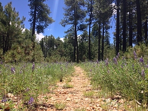
isolated pines, surrounded by forest mess
by nonot

 
Overview
This is a short connector "trail" (an old forest road) used to access the Carr Lake Loop #412.


The only purpose of this trail is to provide a designated connector. It's a nice way to access the loop for those using the Apache Sitgreaves FR9350 Dispersed camping area (42 campsites, first come, first served).

Many will park at the eastern side of this trail at the intersection of FR9350 and FR9350B (driving to here is still legal.)


Hike
The Carr Connector Trail #414 is a quarter-mile portion of an old forest road (FR9350) that is now closed to motorized vehicle travel (except for snowmobiles, which interestingly enough, are allowed on this trail). Due to the 2007 Promontory Fire and forest clearing, there is little shade except for a few isolated pine trees.

Unfortunately, the same forest clearing currently has made a mess of the surrounding, which is not that interesting to look at as it is a mess of bark and tree remnants, along with mud from the loggers tearing up the ground in the area.


The trail ends at the Carr Lake Loop trail (where it leaves this road and proceeds north onto FR9350C.)

Check out the Official Route and Triplogs.

Leave No Trace and +Add a Triplog after your hike to support this local community.

2021-07-18 nonot
    WARNING! Hiking and outdoor related sports can be dangerous. Be responsible and prepare for the trip. Study the area you are entering and plan accordingly. Dress for the current and unexpected weather changes. Take plenty of water. Never go alone. Make an itinerary with your plan(s), route(s), destination(s) and expected return time. Give your itinerary to trusted family and/or friends.

     Permit $$
    None


     Directions
    or
    or
     Road
    FR / Dirt Road / Gravel - Car Okay

    To hike
    From Payson, take highway 260 east to Rim Road. Turn onto the rim road and proceed west about 5.5 miles; turn left (south) off the rim road at FR9350 (this leads to the Carr Trailhead). Rather than turn into the trailhead, continue along FR9350 along the rim for another few miles, passing the 42 dispersed campsites along FR9350. At the last site (#42), you reach the intersection with FR9350B. There is adequate parking here for a few vehicles.
    page created by The_Eagle on Jul 18 2021 4:45 pm
    helpcorrectionissue

    end of page marker