Route Editor

| Guide | ♦ | 40 Triplogs | 2 Topics |
details | drive | no permit | forecast | map |
stats |
photos | triplogs | topics | location |
| 502 | 40 | 2 |
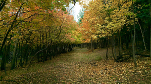
More bear and elk than turkey or beaver by chumley  Description DescriptionThis is a 3300-acre gem of protected land surrounded by some of the most popular recreation areas in the state. Its boundaries are Forest Road 300 on the south, Turkey Creek to the west, and Beaver Canyon to the east. The northern boundary ends at the point where Turkey Creek and Beaver Canyon join. However, the east and west boundaries effectively extend up to the ridges above the canyons where the primary access roads encircle the area; to the west FR115 and FR91, and to the east FR89. Maps often still show FR92 and other roads within the boundary, but these are all now closed to motor vehicle use. There are also countless other old road cuts within this area that provide paths of easy travel. The old 92 road is an excellent way to access the heart of this area, but I highly recommend exploring some of the many old side roads or simply making your own off-trail adventure in this fairly forgiving terrain. There are many wildlife use paths to be found, including well-worn paths in both Beaver Canyon and along Turkey Creek, both of which provide areas of perennial surface water.
In 1983, the ASNFs and AZGFD began to collaboratively plan a habitat management program aimed at reducing impacts by establishing “wildlife habitat areas.” These areas were to improve the quality of habitat for wildlife as well as help protect soil, vegetation, and water resources. The expected benefits and objectives were: • Reduce wildlife disturbance and stress, resulting in healthier animals and populations. • Allow for the more effective use of all available and suitable wildlife habitats. • Increase the value of the outdoor experience. • Greatly improve the hunting experience. • Lengthen the time big game animals stay in the area(s). • Protect vegetation to help preserve soil and water resources. • Reduce road maintenance costs. In 1985, the first five areas were established and were called “wildlife quiet areas” (WQAs). The initial thinking was that the location of WQAs would be rotated across the landscape. In 1988 and 1990, WQAs and associated management objectives were evaluated. Findings included ongoing public support, increased use of the areas by big game and other wildlife species, and improvement in vegetation resources. Regarding rotation of WQAs, it was realized that re-signing new area boundaries every few years would be cost-prohibitive. In addition, State game managers and forest biologists were observing greater affinity (numbers and amount of use) and fidelity toward the areas by wildlife, especially big game and other large mammals. Over the years, WQAs have been eliminated when results were not achieved. Additional WQAs have been added as well, now totaling 8 areas encompassing 2.2% of the Apache-Sitgreaves National Forest. Current proposals include the addition of up to 5 additional areas, reaching 2.8% of forest land. The selection of areas consider the following: • Young bearing and rearing locations • High-quality forage • Good hiding (resting and travel) cover • Critical wintering locations • Location relative to heavily used recreation areas • Need for security within overall heavily populated areas Forest Service reports indicate that visitors witnessed more wildlife in these areas than in non-WQA forest land, including increased numbers of large bull elk and black bear. As of 2017, the 8 WQAs on the Apache-Sitgreaves National Forest are: Beaver Turkey Ridge, Hulsey Bench, Middle Mountain, Open Draw, St. Peters Dome, Upper Coyote, Willow Springs-Horse Trap, and Woolhouse. Proposed areas include Bear Springs, Cottonwood Seep, Carr Lake, Palomino, and Hidden Lake. Information for this description was found in the following forest service publications, which provide much greater detail to interested readers: FS PDF 1 FS PDF 1 Check out the Triplogs. Leave No Trace and +Add a Triplog after your hike to support this local community. | ||||||||||||||||||||||||||||||||||||||||||||||||||||||||||||||||||||||||||||||||||||||||||||||||||||||||||||||||||||||||||||||||||||||||||||||||||||||||||||||||||||||||||||