 Route Editor

| Guide | ♦ | 2 Triplogs | 1 Topic |
details | drive | permit | forecast | 🔥 route |
stats |
photo | triplogs | topic | location |
| 1 | 2 | 1 |
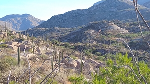
It’s a trail on either end by markthurman53   Overview OverviewThis is a trail on the western slopes of the Catalina Mountains below Samaniego Ridge. Most of these trails in this area are used as mountain bike trails but do see some hikers, especially as you get higher up on Samaniego Ridge's slopes. There is a maze of trails in this area. Many of them are not officially named routes. Signage in this area is nonexistent. This trail is entirely on National Forest, but access is from State Trust land, and a State Trust Land Permit may be required. The locals informed me that hiking in the area didn’t require a permit but parking on state Trust Land probably does. The rules for State Trust Land require that you get a permit if entering Trust Land. I went online and got a year pass for $15.00 to be on the safe side. The Majority of the trails in this area are on National Forest, but the Trailheads are on Trust Land. Accessing this trail is from the Golder Ranch Road Trailhead via the Middle Gate Trail and the 50 Year Upper Trail or the Cherry Tank Trail. Route This trail is a short 1.1 miles that connects the 50 year Upper Trail to the Cherry Tanks Trail. This trail’s eastern end is at the Cherry Tanks Trail, where it crosses Sutherland Creek. The trail heads due west, skirting the south side of an unnamed granite peak, staying well below the 4175-foot summit. After leaving Sutherland Creek, it climbs just over 100 feet to cross over a ridge on this peak's southwest side. The trail from the creek for the first 0.5 miles is easy to follow and appears to get some bike traffic. This is where I ran into difficulty locating the trail; at the peak of the trail, large slabs of exposed granite (slickrock, although it is not slick) become commonplace. Since this is used as a bike trail, I believe the trail follows these slabs, but it is unmarked. For the next 0.5 miles, I could only locate small portions of the trail where it came off the rocks, and I ended up bushwhacking most of the way. The trail follows down this southwest running ridge that comes down off the large granite hill 4175 to the northeast. Once down the ridge, the trail appears again in excellent shape and easy to follow for the last 0.1 miles to the 50 Year Upper trail. Having a GPS with the route is helpful. If you are using this route I have posted, after 0.5 miles in from the east, don’t trust what I have used only as a guide to give general direction. The last 0.2 miles are accurate. The key to following the trail is to think like a biker, stay on the flat granite surfaces where possible, and at about 0.7 miles in, stay on the ridge heading down. Several sucker trails lead down off the ridge to the east and end up going nowhere. If you have the opportunity to load this route on Google Earth, you will see the large granite Slabs at 0.5 miles in where I lost the trail and where I headed down the ridge. I was just to the east of what looks like the trail. Have fun and happy trail hunting.
Check out the Official Route and Triplogs. Leave No Trace and +Add a Triplog after your hike to support this local community. One-Way Notice This hike is listed as One-Way. When hiking several trails on a single "hike", log it with a generic name that describes the hike. Then link the trails traveled, check out the example. | ||||||||||||||||||||||||||||||||||||||||||||||||||||||||||||||||||||||||||||||||||||||||||||||||||


