Route Editor

| Guide | ♦ | 2 Triplogs | 0 Topics |
details | drive | permit | forecast | route |
stats |
photos | triplogs | topics | location |
| 35 | 2 | 0 |
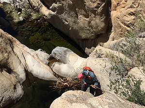
Chino Mystique by rvcarter   Background BackgroundAll hikers going to Elephant Head from the south trailhead off Mt. Hopkins Highway have crossed the Chino Canyon drainage. It is the lowest point along the trail and the climb on both sides of the drainage is quite steep. It is also a nice, shady rest spot either going or coming and has at least a trickle of flow year-round. Looking down canyon to the west, the view is innocent enough, but after a hundred yards or so, the canyon becomes a beautiful but serious tiger intent in preventing anyone from passing unscathed. I found only one substantive reference online, which contained only nine lines of information.
Hike/Climb If you don’t have a high clearance, 4WD vehicle, the logical place to start this hike is the normal trailhead to Elephant Head from the south. The trail to the junction with Chino Canyon is clean, well-marked, and presents nice views of Little and Big Elephant Heads. The valley to the west is beautiful and Baboquivari is visible from much of the trail. The only difficulty along this portion of the trail is the last descent to the canyon (the old road continues to Quantrell Mine) which is steep with loose footing. Another starting point is near the Guzzler along Rd 4073 at the north end of Chino Canyon, west of Elephant Head. The descent into the canyon begins as a nice, benign 500-foot boulder hop. Then you arrive at the first drop at a sharp left-hand turn with a drop of 50+ feet which will have you looking for an anchor point for the rope. Down climbing this section looks daunting, although some people have reportedly done so. We finally noticed the bolted anchor on the right-hand wall about five feet above the ground and 20 or so feet from the start of the rappel. Use this point, because there isn’t much else nearby for setting an anchor. From this point, until you exit the canyon, it is wild and wooly. We saw lion tracks at least two places in the sand. There are lots of pools and flowing water. I cannot remember the specifics of the remaining drops, but they were diverse and interesting. It is fun and challenging to look for anchor set-up points and then rappelling down the polished rock. I recall none of them being longer than 100 feet, but one was exactly 100 feet. There are no true free rappels along the way. The canyon twists and turns while dropping quickly in elevation. When the canyon turns directly north toward the end, don’t miss the fantastic view of Elephant Head towering above, your first since shortly after leaving the trail. Several times, we thought we were emerging from the canyon only to break out the rope again. In fact, a bag for dumping the wet rope into at the end of a drop may be a good idea, rather than coiling and uncoiling the rope multiple times. Most of the early drops are into pools of water which are unavoidable. Finally, the canyon opens up, but there is some scrambling and bush dodging all the way to the old road (Rd 4073), where you turn north or south, depending on where you parked your vehicle. The Canyon The passage of time, and considerable wind and water, have left this canyon with some spectacular rock formations, mostly of polished stone. The footing, regardless of your choice of footwear, is iffy the entire way mainly because your shoes are wet or partially wet after the first drop. We used our gear 8-9 times, which to some may be overly cautious, but, unless your name is Kevin Jorgeson or Tommy Caldwell, it is downright irresponsible to attempt a risky down climb at most of these points. We took rappel rings and webbing for about half a dozen drops. We could have rigged another several anchors with biners and other gear that we would have regretted leaving behind. Luckily, we found the bolted anchor at the first drop and two other safe anchors in good condition with screw ovals along the way left by previous canyoneers. Don’t count on those being in place or safe a few months from now. I've also posted my original track and a greatly scrubbed one. However, once you're in the canyon, there is only one way to go, and that is down. Caution and Recommendations Canyoneering is inherently risky and should be attempted only by groups with one or more people experienced in canyoneering and/or rock climbing, and whose members have a relatively high level of fitness. People not used to hiking off-trail will probably not enjoy this hike/canyon. However, if you like rock scrambling, boulder hopping, and wild canyon bushwhacking, try it, but with at least one person who knows how to set safe anchors in natural terrain. Take enough equipment (webbing, rappel rings or screw ovals, 200-foot rope – or 100-foot rope with pull cord) to do 10 drops. You’ll be glad you did, especially if the canyon is wet. EVERYONE needs to take a harness, ATC, and helmet. Check out the Official Route and Triplogs. Leave No Trace and +Add a Triplog after your hike & climb trip to support this local community. | |||||||||||||||||||||||||||||||||||||||||||||||||||||||||||||||||||||||||||||||||||||||||||||||||||||||||||||||||||