Route Editor

| Guide | ♦ | 4 Triplogs | 0 Topics |
details | drive | permit | forecast | route |
stats |
photos | triplogs | topics | location |
| 80 | 4 | 0 |
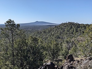
Freddy Would Paint the Views in Every Direction. by pseudalpine   Overview OverviewLocated at the south end of the prominent Shivwits Plateau and its extinct volcanic field, Mount Dellenbaugh is the highest point in Lake Mead National Recreation Area and the second most prominent to Spirit Mountain. It’s located on the area’s north-central border with the trailhead located at the southern boundary of Grand Canyon - Parashant National Monument. History The mountain is named after artist and assistant topographer Frederick S. Dellenbaugh, who was part of Powell’s second expedition in 1870-71. It’s speculated that W. Dunn and the two Howland brothers who prematurely abandoned Powell’s first 1869 expedition may have ascended to the summit of this mountain to orientate themselves after exiting via Separation Canyon. We know that they vanished without a trace, but the details of their disappearance remain only conjecture to the present day.
The lower (first) section of trail has been realigned away from the old jeep road that tracks south from the government administration site (Five Guard Camp). It starts relatively flat as a single track that passes through Big Sagebrush, Utah Juniper, Gambel Oak but mainly Ponderosa Pine. There’s a barbed wire fence with a gate where the trail enters Lake Mead NRA and then bears more west until joining the old two-track at about 0.75 miles. The trail then tracks predominantly southwest, angling briefly through Grand Canyon – Parashant NM at the 1.5-mile point. The forest becomes dominated more by mistletoe-infested Juniper and a few Twoneedle pinyon. The trail isn’t overly rocky except for a few obscure sections that have eroded. It’s generally easy to follow being mostly rock-lined with logs blocking one side of the old two-track. The reddish-brown clay soil that makes up most of the trail would be a super squishy mud fest during wet periods. The last half mile sweeps through some broad switchbacks where the forest is more a New Mexico Locust and Bigtooth Maple shrubbery. There’s one decent overlook at a saddle before the final push to the much better vantage point at the top, where a final scramble is over black lava boulders. It’s nothing that would be considered overly taxing to regular or experienced hikers. There’s a solar panel array tucked into the north side of the peak (possibly a weather station), an ammo can register, and a few benchmarks at the bouldery summit. Synopsis Just graded at a moderate technicality (low AEG) with great views abounding in every direction from the apex. To name a few points of interest, to the south is western Grand Canyon including Twin Point and Spring Canyon, the Hualapai Mountains, and Mount Charleston. The Unikaret Mountains dominate the eastern view, and the Pine Valley Mountains are discernable to the north. To the west are the Grand Wash Cliffs and the more distant Virgin Mountains. There is some shade available from the Juniper trees along the way, in spite of what the trailhead signage informs otherwise. Gate Policy: If a gate is closed upon arrival, leave it closed after you go through. If it is open, leave it open. Leaving a closed gate open may put cattle in danger. Closing an open gate may cut them off from water. Please be respectful, leave gates as found. The exception is signage on the gate directing you otherwise. Check out the Official Route and Triplogs. Leave No Trace and +Add a Triplog after your hike to support this local community. | ||||||||||||||||||||||||||||||||||||||||||||||||||||||||||||||||||||||||||||||||||||||||