 Route Editor

| Guide | ♦ | 55 Triplogs | 0 Topics |
details | drive | no permit | forecast | route |
stats |
photos | triplogs | topics | location |
| 128 | 55 | 0 |
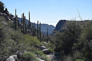
where crested saguaros hide by markthurman53  Overview OverviewConnects the Wild Burro Trail near Alamo Spring to the Upper Javelina Trail and eventually the Wild Burro Trail near the Ritz Carlton Hotel. This trail follows along and below a ridge that separates Wild Burro Canyon from Cochie Canyon. This ridge is a northeast-southwest trending ridge so while the views are great they are limited to a southerly direction between the Catalina Mountains and the Tucson Mountains and on a clear day all the way to the Quinlan Mountains. There are a couple crested saguaros along this trail and from videos I have seen wild horses also. This trail by its location is going to be part of a greater loop trail. There is no trailhead for this trail; access is via the Wild Burro Trail just north of Alamo Spring or a combination of the Wild Burro and Upper Javelina Trail.
The Wild Mustang Trail starts from the Wild Burro Trail about 0.4 miles north of Alamo Spring at a signed intersection. Soon you pass through a gate, not sure what boundary this is marking because this part of the trail is well within the Tortolita Mountain Park, maybe they still run cattle? At about 0.2 miles the trail crosses a wash, this is the same wash that enters Alamo Spring from the north. The trail crosses a wash that the route to Cochie Canyon Spring heads up. Stay on the well-defined trail. From this point, the trail starts a 500-foot climb up to a saddle below the ridge that separates Cochie from Wild Burro Canyon. Two false saddles are crossed before the final saddle and I kept thinking I was there only to be fooled. The climb up is not strenuous but it is steady. As you ascend to the lower of the three saddles there are some great views over Wild Burro Upper Canyon and Alamo Spring. From here the views to the south and west become more prominent. The trail continues following below the ridge and remains fairly level before dropping down into the first of two drainage systems coming off of the ridge and heading down into Wild Burro Canyon. The trail does a continuous gradual descent to the Upper Javelina Trail. At 0.3 miles from the Upper Javelina Trail the Cochie Trail comes in from the west and the Wild Burro Trail makes a hard turn to the east. Note Keep an eye peeled for the crested saguaros along this trail, I was told there were a couple but I didn’t see any and I was looking. I also didn’t see any wild horses. This trail has a lot of sun exposure so keep that in mind when planning this as part of a greater loop trail. I have heard this is the best trail in the Tortolitas but I think it is second to the Ridgeline Trail. Gate Policy: If a gate is closed upon arrival, leave it closed after you go through. If it is open, leave it open. Leaving a closed gate open may put cattle in danger. Closing an open gate may cut them off from water. Please be respectful, leave gates as found. The exception is signage on the gate directing you otherwise. Check out the Official Route and Triplogs. Leave No Trace and +Add a Triplog after your hike to support this local community. One-Way Notice This hike is listed as One-Way. When hiking several trails on a single "hike", log it with a generic name that describes the hike. Then link the trails traveled, check out the example. | ||||||||||||||||||||||||||||||||||||||||||||||||||||||||||||||||||||||||||||||||||||||||||||||||||||||||||||||||||||||||||||||||||||||||||||||||||||||||||||||||||||||||||||||||||||||||||||


