 Route Editor

| Guide | ♦ | 4 Triplogs | 0 Topics |
details | drive | permit | forecast | route |
stats |
photos | triplogs | topics | location |
| 16 | 4 | 0 |
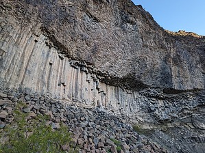
Dam, that's Igneous! by pseudalpine   Overview OverviewA relatively easy Grand Canyon trail that descends nearly one thousand feet to the Colorado River at the southern end of the Uinkaret Plateau. The trailhead is located at Whitmore Canyon Overlook of Lake Mead National Recreation Area. There are several car camping spots at the overlook that do not require a permit. This area is likely categorized as Mojave Desert, but the landscape and flora of these steep southern slopes seem very similar to the Sonoran Desert. Hike The trail begins from the numerous freedom camps heading south amongst many large ocotillo and stays flat for the first tenth of a mile. A sign informs hikers that permits are required for overnight trips when the trail enters Grand Canyon National Park. After two mellow switchbacks, the trail descends through a lava field and progresses through and over black boulders for another half mile. At the half-mile point, the trail passes below an impressive columnar jointed basalt cliff. This area is probably the highlight of this trail as the beach area at the trail's two unambiguous termini aren't really distinct from many other Grand Canyon beaches.
When compared to other Grand Canyon trails, this route isn't particularly challenging when completed in the opportune season. It definitely gets dangerously hot on this route, but it probably wouldn't be as a desperate situation as the Lava Falls Route would be in extreme heat. I'd imagine this area would be a straightforward location for anglers to access the river and perhaps a good way to explore lower Whitmore Canyon slightly downstream. It also would be a convenient exit trail/shuttle for packrafters who've completed exploring upstream. Check out the Official Route and Triplogs. Leave No Trace and +Add a Triplog after your hike to support this local community. One-Way Notice This hike is listed as One-Way. When hiking several trails on a single "hike", log it with a generic name that describes the hike. Then link the trails traveled, check out the example. | |||||||||||||||||||||||||||||||||||||||||||||||||||||||||||||||||||||||||||||||||||||


