username
X
password
register
for free!
help


Chain Fruit Trail, AZ

Guide 36 Triplogs  0 Topics
  2 of 5  
Fav
Wish
0
details
drive
permit
forecast
route  
stats
photos
triplogs
topics
location
58 36 0
Statistics
tap row or icons for details
Route Finding 1 of 5
Distance One Way 1 mile
Trailhead Elevation 1,886 feet
Elevation Gain 92 feet
Accumulated Gain 95 feet
Avg Time One Way 0.3
Kokopelli Seeds 1.32
 Backpack No
feature photo
Photos Viewed All MineFollowing
5  2025-07-13
Meridian Trail
DarthStiller
11  2025-04-27
Merkle Memorial Trail
DarthStiller
5  2025-03-16
Amigos Wash Trail
DarthStiller
6  2024-11-23
Talon Trail
DarthStiller
5  2024-09-16
Lost Sheep Trail
Tortoise_Hiker
7  2024-06-02
Blevins Trail
DarthStiller
10  2024-05-14
Lost Sheep Trail
Tortoise_Hiker
11  2024-03-31
Talon Trail
DarthStiller
Page 1,  2,  3
Author
author avatar Guides 27
Routes 669
Photos 12,096
Trips 856 map ( 8,047 miles )
Age 56 Male Gender
Location Mesa, AZ
Associated Areas
list map done
Phoenix Region
Historical Weather
Trailhead Forecast
Radar Map
Expand Map
Preferred Oct, Jan, Feb, May
Seasons   Late Autumn to Late Spring
Sun  6:02am - 6:48pm
Official Route & 2 Rts
 
14 Alternative


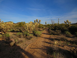
Swinging at the chains
by DarthStiller

 
Overview
The southern end connects to the northwest corner of the Blevins Trail, 0.1 miles north of the beginning of the Moon Rock Trail. The northern end of it connects to the Lost Sheep Trail, a half-mile south of the Nature Center. There are two also spur trails along the trail that connect to the campground areas inside the park.


Hike
The trail is mostly level, having a very moderate climb heading northwest, just over 90 feet in one mile. Pass Mountain is prominent to the east, and "Phoenix" mountain to the north. To the west through the vegetation glimpses of the Sierra Estrella in the distance can be seen at times, along with an occasional view of the nearby house at the top of the hill.
remove free decal offer
The predominant vegetation is obviously chain fruit chollas, but the typical gang of Sonoran desert plants such as saguaros and creosote are also in abundance.

2019-01-21 DarthStiller
  • Usery Trails 2019 Map
    area related
    Usery Trails 2019 Map
  • Usery Trails 2019 Map
    area related
    Usery Trails 2019 Map


Check out the Official Route and Triplogs.
Leave No Trace and +Add a Triplog after your hike to support this local community.

One-Way Notice
This hike is listed as One-Way.

When hiking several trails on a single "hike", log it with a generic name that describes the hike. Then link the trails traveled, check out the example.
WARNING! Hiking and outdoor related sports can be dangerous. Be responsible and prepare for the trip. Study the area you are entering and plan accordingly. Dress for the current and unexpected weather changes. Take plenty of water. Never go alone. Make an itinerary with your plan(s), route(s), destination(s) and expected return time. Give your itinerary to trusted family and/or friends.

 Permit $$
Maricopa Regional Parks - 2024 [ fees ]

$7 per vehicle, $85 annual or trade your firstborn for the life pass

$2 walk, bike, or horse ride into the park

2024 [ hours ] - varies by park & season


 Directions
or
 Road
Paved - Car Okay

To hike
Inside Usery Park, park at the small parking lot at the southwest corner of the Blevins Drive loop. Take the trail past the picnic area to the Blevins Trail to access the south end of the trail.

Access to the north end is from the Nature Center along Usery Park Road just inside the park entrance.
page created by DarthStiller on Jan 21 2019 1:10 pm
 90+° 8am - 6pm kills
helpcorrectionissue

end of page marker