 Route Editor

| Guide | ♦ | 33 Triplogs | 0 Topics |
details | drive | no permit | forecast | 🔥 route |
stats |
photos | triplogs | topics | location |
| 510 | 33 | 0 |
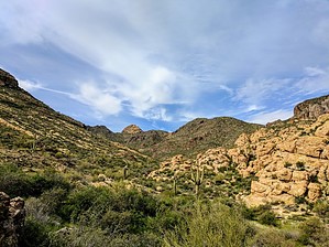
sandy wash hike by markthurman53  Overview OverviewThis Trail follows along the upper portion of Willow Springs Canyon from The Willow Springs Canyon Trailhead along the Apache Highway to The junction with The Rough and Ready Trail. This trail pretty much follows the creek the whole way. The first 2 miles are along a 2 track jeep trail, FSR 12, sometimes in the creek bed other times to the side of the creek to bypass obstacles in the wash. A natural continuation of this trail at the junction with the Rough N Ready trail would be to continue down the creek to Saguaro Lake along Willow Springs Canyon Lower Trail. Willow Springs Canyon and the Rough and Ready Trails are the main North-South Trails from which many loop hikes can be created. This trail is the main access to either Willow Springs Basin and Tank or Bagley Tank. This is an easy trail to hike but involves a lot of in-wash and therefore a lot of sand. None of these trails are marked so a good GPS route ahead of time is a good idea. As usual, the normal precautions for hiking in washes should be observed, flash flooding is possible. While this can occur at any time it is particularly an issue in the summer during the monsoon season. This is not a summer-friendly place for humans since it is located in the low desert and temperatures well over 100 degrees are common. Probably isn’t summer friendly for the animals that live out there either but they have learned how to deal with it.
This trail starts at the Willow Springs Canyon Trailhead along the Apache Highway near Mile Post 204. There is plenty of parking to the north of the road. From the get-go, you are on a 2 track that drops into Willow Springs Creek after about a quarter-mile. When you drop into the creek there is a trail that heads due west, this is the Javelina Willow Springs Canyon Crossover (western portion known as the Gold Eagles Nugget Trail). Ignore this trail for now. Continue following the 2-track down the wash. The 2 track will follow the wash for about a half mile before exiting the wash and staying to the east of the creek bed for about a half-mile to avoid constrictions in the creek. If you are on foot, stay in the creek bed to see Willow Springs. This is an interesting part of the creek, second only to where Willow Springs Canyon is Joined by Rough N Ready Canyon (I am assuming this is the name of this canyon, couldn’t find that on any map but everybody seems to know it by that name). At a little over a mile in the 2 track rejoins the wash and stays pretty much in the wash. There is a lot of sand walking along this stretch. At 2 miles in the 2 track departs and heads to Bagley Tank. Continue down the wash for a couple tenths of a mile and the wash takes a bend to a more westerly direction and then back to the north again. At this bend there are two trails about a tenth of a mile apart that go toward Willow Springs Basin Tank. Ignore these also unless that’s where you want to go. Just after the wash turns toward the north again there is a trail marked by a cairn that heads west over the ridge and drops down into Rough N Ready Canyon. Ignore this one too. Continue down Willow Springs Canyon for another 1.2 miles to the Junction with the Rough N Ready Canyon. The last 0.7 miles of this trail are probably the most interesting along this trail. The canyon narrows and wind around cliffs of light-colored Rhyolite and dark basaltic flows. Be careful not to stumble on the rocks in the canyon as you gawk at the scenery all around you. Return can be either the way you came or a loop can be created going up the Rough N Ready Trail and taking one of the trails that cut back over to Willow Springs Canyon (Rough N Ready Willow Springs Crossover, Quartz Crystal Arroyo and Javelina Willow Springs Crossover also known as the Gold Eagles Nugget Trail) Check out the Official Route and Triplogs. Leave No Trace and +Add a Triplog after your hike to support this local community. One-Way Notice This hike is listed as One-Way. When hiking several trails on a single "hike", log it with a generic name that describes the hike. Then link the trails traveled, check out the example. | |||||||||||||||||||||||||||||||||||||||||||||||||||||||||||||||||||||||||||||||||||||||||||||||||||||||||||||||||||||||||||||||||||||||||||||||||||||||||||||||||||||||||||||||||||||||


