 Route Editor

| Guide | ♦ | 21 Triplogs | 0 Topics |
details | drive | no permit | forecast | 🔥 route |
stats |
photos | triplogs | topics | location |
| 0 | 21 | 0 |
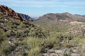
Golden Eye Arch route by markthurman53  Overview OverviewThe Willow Springs Tank Trail has its Southern Terminus at the junction with the Javelina Willow Springs Crossover (Gold Eagles Nugget Trail) and the Javelina Mine Trail. The northern terminus is at the Willow Springs Canyon Trail. A good portion of this trail is known as the Golden Eye Mine Trail. This trail crosses over from the Quartz Crystal Arroyo into the Willow Springs Basin and follows the basin along the western side past Golden Eye Arch and Willow Springs Tank before connecting up with the Willow Springs Canyon Trail. Willow Springs Tank is not directly on this trail but the Willow Springs Tank Spur (0.2 miles) leads to the tank. Its sister trail Willow Springs Basin Trail is just across the way on the eastern slopes of Willow Springs Basin. Hike From the junction with the Javelina Mine Trail and the Javelina Willow Springs Crossover (Gold Eagles Nugget Trail) the trail heads down the upper portion of Quartz Crystal Arroyo for 0.1 miles before heading up a small ridge (a very small ridge) overlooking Willow Springs Basin. This is a good spot to step off trail a couple of feet to the north onto a rock that allows good views over Willow Spring Basin. From here it is downhill for about 0.4 miles to the junction with the Golden Eye Arch Route. Continuing on another 0.2 miles the trail crosses an old 2 track that leads to Willow Springs Basin Tank (Willow Springs Tank Spur). It is 0.2 miles to the tank. The trail crosses over the 2 track and continues for just under 0.5 miles to the junction with the Willow Springs Canyon Trail. This trail is in good shape and looks like it gets a lot of use. Check out the Official Route and Triplogs. Leave No Trace and +Add a Triplog after your hike to support this local community. One-Way Notice This hike is listed as One-Way. When hiking several trails on a single "hike", log it with a generic name that describes the hike. Then link the trails traveled, check out the example. | |||||||||||||||||||||||||||||||||||||||||||||||||||||||||||||||||||||||||||||||||||||||||||||||||||||||||||||||||||||||||||||||||||||||||||||||||||||||||||||||||||||||||||||||||||||||||||


