| Guide | ♦ | 45 Triplogs | 2 Topics |
details | drive | permit | forecast | route |
stats |
photos | triplogs | topics | location |
| 345 | 45 | 2 |
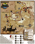
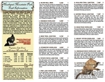
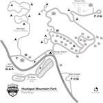
Pine Tree Folk by leadhiker  The Hualapai Mountains rise abruptly southeast of Kingman offering hikers a contrast to the parched desert basins below. Mohave County established the park in 1937, and the Civilian Conversation Corps built the first cabins and trails. The trails were rebuilt by the Youth Conservation Corps in 1981. On my hike on June 30, 2009, I came across a group from the Mohave Sheriffs Probation Department doing trail maintenance. If you only have enough time to do one hike in northwest Arizona, this should be the one. The Hualapai Indians (pine tree folk) regard the nuts of the pinon pine common to the mountains to be a valuable food source. Eventually, the name of the people became the name of the mountains. The Indian tribe called these mountains home until they were relocated by the military in the 1870s. The Hualapai Mountains rise abruptly southeast of Kingman offering hikers a contrast to the parched desert basins below. Mohave County established the park in 1937, and the Civilian Conversation Corps built the first cabins and trails. The trails were rebuilt by the Youth Conservation Corps in 1981. On my hike on June 30, 2009, I came across a group from the Mohave Sheriffs Probation Department doing trail maintenance. If you only have enough time to do one hike in northwest Arizona, this should be the one. The Hualapai Indians (pine tree folk) regard the nuts of the pinon pine common to the mountains to be a valuable food source. Eventually, the name of the people became the name of the mountains. The Indian tribe called these mountains home until they were relocated by the military in the 1870s.There are over ten miles of trails in the park ranging in elevation from 6200 feet at Sawmill Canyon to Hualapai Peak at 8417 feet. All of the trails are easy to follow and have numbered trail markers that coincide with a map. Be sure to get one when you pay your entrance fee. There are benches and storm shelters along the trail.
From the parking lot walk up the road past the locked gate about 75 yards. The Aspen Springs Trail starts on the left side of the road. Follow this trail 0.86 miles to the junction of the Potato Patch Trail. Turn right and follow the loop counterclockwise. The summit of Aspen Peak will come into view in a short distance. A great view of the Kingman basin and the Cerbat Mountains to the northwest are just past an interesting rock formation known at the Three Gossips. Just past the first storm shelter the trail levels off and you come to a 4WD road. This connects with the road to the Boy Scout Camp. Stay left on the road and in a short distance you will come to the trail to Aspen Peak. It is about a 1.4 mile, steep climb, round trip to Aspen Peak. To continue on the loop follow the dirt road downhill to the Boy Scout Camp. About 0.25 miles past the camp the Potato Patch Trail turns left off the road into the bush. The turn is signed but, easy to pass by. The Potato Patch Trail climbs briefly and then contours around the east side of Aspen Peak. You have great views of Hualapai and Hayden Peaks to the south. After 3.5 miles of hiking, you'll connect back with the Aspen Springs Trail. Return to the parking lot via the Aspen Springs Trail. Gate Policy: If a gate is closed upon arrival, leave it closed after you go through. If it is open, leave it open. Leaving a closed gate open may put cattle in danger. Closing an open gate may cut them off from water. Please be respectful, leave gates as found. The exception is signage on the gate directing you otherwise. Check out the Official Route and Triplogs. Leave No Trace and +Add a Triplog after your hike to support this local community. | |||||||||||||||||||||||||||||||||||||||||||||||||||||||||||||||||||||||||||||||||||||||||||||||||||||||||||||||||||||||||||||||||||||||||||||||||||||||||||||||||||||||||||||||||||||||||||||
 Route Editor


