 Route Editor

| Guide | ♦ | 4 Triplogs | 0 Topics |
details | drive | permit | forecast | 🔥 route |
stats |
photos | triplogs | topics | location |
| 45 | 4 | 0 |
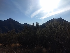
steer clear of the sheer cliffs by ShatteredArm  Overview OverviewPete Mountain is a minor summit on a long ridge connecting Mount Hopkins, Agua Caliente Saddle, and Elephant Head. There is an unofficial trail from Agua Caliente Saddle to Pete Mountain, which affords excellent views of the Santa Rita high country and the Santa Cruz valley. Hike You first have to get to Agua Caliente Saddle from Agua Caliente TH (~2.7 miles) or Madera Canyon (~1.8 miles via Vault Mine Trail). Either way is a significant effort, so factor this into your plans.
As the trail continues along the ridge, there are a couple of spots where it is easy to get off the track, but it is usually near the crest. If you're heading down the side of the ridge rather than along it, you're probably off track. The first half mile or so is a net elevation loss. The low point of the route is a large saddle where there are some pine trees and a decent campsite. From here, it is a steep 500-foot climb to the summit of Pete Mountain. The trail generally stays on the south side of the ridge at this point, but if you lose the trail, it's probably best not to go too far south, as there is a sheer cliff on that side of the peak. At the summit (marked by a large cairn with a register), the trail ends, and the vegetation is generally transitional scrub like holly, manzanita, juniper, etc. To the west, you can see the Baboquivari Mountains, and to the east you see Mount Hopkins, Mount Wrightson, and the Santa Rita crest. Water Sources There are no water sources along this trail. If you start at Agua Caliente TH, there is seasonal water in Agua Caliente Canyon. Check out the Official Route and Triplogs. Leave No Trace and +Add a Triplog after your hike to support this local community. One-Way Notice This hike is listed as One-Way. When hiking several trails on a single "hike", log it with a generic name that describes the hike. Then link the trails traveled, check out the example. | |||||||||||||||||||||||||||||||||||||||||||||||||||||||||||||||||||||||||||||||||||||||||||||||||||


