Route Editor

| Guide | ♦ | 17 Triplogs | 0 Topics |
details | drive | no permit | forecast | 🔥 route |
stats |
photos | triplogs | topics | location |
| 137 | 17 | 0 |
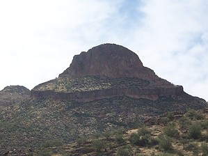
On the Razor's Edge by DixieFlyer  Overview OverviewRazorback (2,812') is a fin-shaped formation of tertiary rhyolite in the central Goldfields. Hike The preferred way to hike to Razorback begins and ends at the Willow Springs TH, which is at mile marker 204 on Highway 88 in Apache Junction. While there are no "official" trails to follow, there is a good network of trails that will take you most of the way to Razorback. Note that there is no signage on the trails, and there are several junctions along the way where trails fork. As a result, it is recommended that hikers bring along some combination of GPS tracks, topographic maps, and a compass.
The easiest way to get on top of Razorback is from the west side of the formation. This GPS track from hikerdw shows a good route to take up to the summit of Razorback. While Razorback looks intimidating to climb, this route is quite easy for experienced hikers. Check triplogs for routes that other hikes may have taken. The 360-degree views atop Razorback are fantastic -- Four Peaks, Saguaro Lake, Weaver's Needle, The Flatiron, Golden Dome, Dome Mountain, and Panorama Peak are just a few of the landmarks that are readily seen. It is also a lot of fun to transverse Razorback's spine, which runs for a couple of hundred feet. Caution The Razorback's spine is probably no more than about 5 feet wide, and it is more narrow than that in places. There are vertical dropoffs on both sides of the spine that descend a substantial distance in many places. Those that have a fear of heights may not want to walk around much atop Razorback. Check out the Official Route and Triplogs. Leave No Trace and +Add a Triplog after your hike to support this local community. | ||||||||||||||||||||||||||||||||||||||||||||||||||||||||||||||||||||||||||||||||||||||||||||||||||||||||||||||||||||||||||||||||||||||||||||||||||||||||||||||||||||||||||||||||||||||||||||||||||