Overview
The Anniversary Arch Loop is a short 1.2-mile loop off of Rough N Ready. This Loop is short and only climbs a little over 200 feet but it is packed with scenery and rock formations. Anniversary Arch is interesting but I thought the views won the prize. There are a lot of offshoot paths that split off, some of them going to different viewpoints along the ridge. One offshoot takes you down the west side of the ridge down into Cottonwood Canyon making this an excellent crossover trail.
Description
The Anniversary Arch loop begins and ends along Rough N Ready about 1.7 miles north of the Rough N Ready Junction with the Javelina Mine Trail. This description is in the counterclockwise direction. I chose the CCW direction because the 200-foot climb to the ridge is more gradual this way.
The first 0.3 miles to a saddle near the top of a ridge is a gradual climb along a small wash. There are great views to the left of the rock cliffs below the ridge that the trail will eventually go along. Once on the saddle, there is a trail that continues west, this trail heads down into Cottonwood Wash. Continue on the Anniversary trail up to the ridge. Two trails follow along the ridge, one of them follows higher up on the ridge the other slightly lower on the west side of the ridge. I chose the upper.
Anniversary Arch is alongside the upper trail. There are great views to the northwest of Goldfield Mountain and Cottonwood Wash and the east toward Willow Springs Basin. From Anniversary Arch the trail starts descending back down to finish the loop. I thought this descent was steeper than the way I came up. This is a nice little side trip that doesn't require a lot of energy but packs many rewards (more bang for the buck). So even if your hike is a longer loop hike this little side trip is probably worth it.
When hiking several trails on a single "hike", log it with a generic name that describes the hike. Then link the trails traveled, check out the example.
WARNING! Hiking and outdoor related sports can be dangerous. Be responsible and prepare for the trip. Study the area you are entering and plan accordingly. Dress for the current and unexpected weather changes. Take plenty of water. Never go alone. Make an itinerary with your plan(s), route(s), destination(s) and expected return time. Give your itinerary to trusted family and/or friends.
Permit $$
None
Directions
Road
Connector trail - Not Applicable
To hike From Apache Junction take AZ88 2 miles past the Lost Dutchman Park entrance. This is the Javelina Mine Trailhead. Take Javelina Mine Trail to the Rough and Ready Trail. Rough N Ready trail for 1.7 miles to the Anniversary Arch Loop.
page created by markthurman53 on Feb 23 2020 9:18 pm
 Route Editor

 Overview
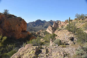


