username
X
password
register
for free!
help
 
   🔥

Johnson Peak - Chiricahua Wilderness, AZ

Guide 4 Triplogs  0 Topics
  2.5 of 5  
Fav
Wish
0
details
drive
permit
forecast
🔥
route  
stats
photos
triplogs
topics
location
70 4 0
Statistics
tap row or icons for details
Difficulty 3 of 5
Route Finding 3 of 5
Distance Round Trip 0.5 miles
Trailhead Elevation 8,547 feet
Elevation Gain 343 feet
Accumulated Gain 343 feet
Avg Time Round Trip 30 minutes
Kokopelli Seeds 2.22
 Interest Off-Trail Hiking & Peak
 Backpack Yes
unreported if dogs are allowed
editedit > ops > dogs to adjust
feature photo
Photos Viewed All MineFollowing
38  2023-09-14 Mike_W
12  2020-05-24
Chiricahua Peak Loop
LJW
20  2020-05-07
Chiricahuas: Monte Vista Peak - Johnson Peak
DixieFlyer
Author
author avatar Guides 99
Routes 1,484
Photos 16,072
Trips 1,374 map ( 13,602 miles )
Age Male Gender
Location Fountain Hills, AZ
Associated Areas
list map done
Tucson Region
Historical Weather
Trailhead Forecast
Radar Map
Expand Map
Preferred Apr, May, Nov, Oct
Seasons   Spring to Late Autumn
Sun  5:54am - 6:38pm
Official Route
 
3 Alternative
 
Historic Fire Perimetersacres
🔥 2011 Horseshoe 2 Fire158.9 mi*
🔥 1994 Rattlesnake Fire50.4 mi*
🔥 View (All) - over Official Route 🔥
*perimeter length in miles


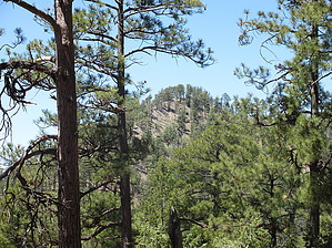
Feel the Johnson
by DixieFlyer

 
Overview
Johnson Peak (elevation of 8,890' with 330' of prominence) is a peak in the western Chiricahua Mountains that is near Monte Vista Peak.


Hike
The climb up to Johnson Peak is off-trail and begins at the trail junction of Morse Canyon Trail #43 and Turtle Mountain Trail #219. From the trail junction, you initially climb southwest to a ridgeline that goes up the west side of Johnson Peak. Once on the ridgeline, just stay on the spine of the ridgeline to the summit. There is a barb wire fence on the spine that is mostly on the ground that you can follow up to the summit.
remove free decal offer
The initial climb up to the ridgeline is a bit steep and is mostly on pine needles that can be a bit slippery. Once on the ridgeline, there is a lot of solid rock that enhances your footing. Note that there is some occasional deadfall that you might have to navigate around.

There are some pine trees at the summit that limit your views. However, you do have a nice view of Monte Vista Peak and the Monte Vista Fire Lookout.

This is not likely to be a summit that you want to make a special trip to the Chiricahuas to do; however if you are hiking up to nearby Monte Vista Peak or if you are doing the Johhson Peak Loop Hike then hiking up to Johnson Peak might be of interest, particularly if you are a peakbagger.

2020-05-09 DixieFlyer


    Check out the Official Route and Triplogs.
    Leave No Trace and +Add a Triplog after your hike to support this local community.
    WARNING! Hiking and outdoor related sports can be dangerous. Be responsible and prepare for the trip. Study the area you are entering and plan accordingly. Dress for the current and unexpected weather changes. Take plenty of water. Never go alone. Make an itinerary with your plan(s), route(s), destination(s) and expected return time. Give your itinerary to trusted family and/or friends.

     Permit $$
    None

    Coronado Forest
    MVUMs are rarely necessary to review unless mentioned in the description or directions
    Coronado Motor Vehicle Use Maps (MVUMs)


     Directions
    or
     Road
    FR / Dirt Road / Gravel - Car Okay

    To hike
    The easiest way to get to Johnson Peak is to begin your hike from the Morse Canyon Trailhead. This trailhead is an 11-mile drive to the very end of Turkey Creek Rd (FR 41). The road is unpaved. Most vehicles can drive it when dry. Note that the last 3 miles of the road are a bit narrow and rocky. For detailed directions, see the directions in the guide for Morse Canyon Trail #43.
    page created by DixieFlyer on May 09 2020 6:20 pm
     90+° 8am - 6pm kills
    helpcorrectionissue

    end of page marker