 Route Editor

| Guide | ♦ | 5 Triplogs | 0 Topics |
details | drive | permit | forecast | 🔥 route |
stats |
photos | triplogs | topics | location |
| 150 | 5 | 0 |
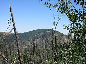
Ain't no sunshine when it snows by DixieFlyer   Overview OverviewSnowshed Peak (elevation of 9,665' with 364' of prominence) is one of several 9,000' or higher peaks that can be accessed from Crest Trail #270 along the Chiricahua Mountains Ridgeline. Hike As the crow flies, Snowshed Peak is about 1.5 miles southeast of Chiricahua Peak.
For purposes of this guide, the hike begins at the junction of the west end of Snowshed Trail #246 and Crest Trail #270C, near Juniper Saddle. From the junction, follow Snowshed Trail #246 for under a 1/2 mile to Snowshed Saddle, which is in between Aspen Peak (to the west of the saddle) and Snowshed Peak (to the east of the saddle). This section of Snowshed Trail #246 is well defined and is easy to hike on and to follow. At the saddle, Snowshed Trail #246 loops around to the south of Snowshed Peak as it makes its way for 7-8 miles down into Cave Creek Canyon. Note that there are no trail markers at the saddle. From the saddle, take Snowshed Peak Trail #364 up to the summit of Snowshed Peak. However, that is easier said than done because Trail #364 basically no longer exists. From the saddle, you can see a cairn or two, and there are faint outlines of a trail in a place or two. Initially, it does not matter whether there is a trail or not, as the area is wide open and you can clearly see Snowshed Peak above you. However, before long you find yourself in an area of thick vegetation (mostly young aspen trees growing very close together) and quite a bit of deadfall. To top it off, some rock and boulder fields need to be navigated. Just keep going uphill, and with some perseverance, you can make it to the summit. From the saddle, you'll go about 1/2 mile up to the summit. The summit is at or very near these coordinates: 31.83902, -109.26732 At the summit, some trees limit the views; this is typical of many peaks in the Chiricahuas. However, at the summit, there are some nice views to the south and toward the east. Descend the same way that you came up. Synopsis This is a worthy hike to do, especially if you are a peakbagger. However, the last 1/2 mile to the summit is an off-trail bushwhack, but it is not an especially difficult bushwhack. Check out the Official Route and Triplogs. Leave No Trace and +Add a Triplog after your hike to support this local community. One-Way Notice This hike is listed as One-Way. When hiking several trails on a single "hike", log it with a generic name that describes the hike. Then link the trails traveled, check out the example. | ||||||||||||||||||||||||||||||||||||||||||||||||||||||||||||||||||||||||||||||||||||||||||||||||||||||||


